IMAGES TAKEN NEAR TO
Bonchurch Avenue, LEIGH-ON-SEA, SS9 3AR
Introduction
This page details the photographs taken nearby to Bonchurch Avenue, SS9 3AR by members of the Geograph project.
The Geograph project started in 2005 with the aim of publishing, organising and preserving representative images for every square kilometre of Great Britain, Ireland and the Isle of Man.

There are currently over 7.5m images from over14,400 individuals and you can help contribute to the project by visiting https://www.geograph.org.uk
Image Map
Images are licensed for reuse under creativecommons.org/licenses/by-sa/2.0
Notes
- Clicking on the map will re-center to the selected point.
- The higher the marker number, the further away the image location is from the centre of the postcode.
Image Listing (7 Images Found)
Images are licensed for reuse under creativecommons.org/licenses/by-sa/2.0
Image
Details
Distance
1
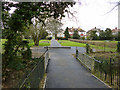
Bonchurch Recreation Ground
The path crosses Prittle Brook in the foreground.
Image: © Robin Webster
Taken: 28 Feb 2016
0.11 miles
2
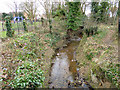
Prittle Brook
Running along the south side of Bonchurch Recreation Ground, looking downstream.
Image: © Robin Webster
Taken: 28 Feb 2016
0.13 miles
3
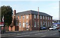
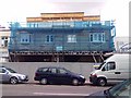
Sorting Office, Leigh-on-Sea
The Royal Mail Sorting Office, London Road, Leigh-on-Sea.
Image: © Paul Collins
Taken: 9 Aug 2007
0.21 miles
4
Houses on Blenheim Chase
Looking from the end of St Clements Drive.
Image: © Robin Webster
Taken: 28 Feb 2016
0.22 miles
6
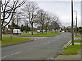
Blenheim Chase
Looking towards the lights at the junction with Elmsleigh Drive.
Image: © Robin Webster
Taken: 28 Feb 2016
0.24 miles
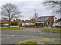
7
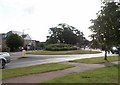
Roundabout
Roundabout, junction of Eastwood Road North, Eastwood Road and Blenheim Chase, looking East.
Image: © Paul Collins
Taken: 27 Jul 2007
0.24 miles