IMAGES TAKEN NEAR TO
Salisbury Road, LEIGH-ON-SEA, SS9 2JX
Introduction
This page details the photographs taken nearby to Salisbury Road, SS9 2JX by members of the Geograph project.
The Geograph project started in 2005 with the aim of publishing, organising and preserving representative images for every square kilometre of Great Britain, Ireland and the Isle of Man.

There are currently over 7.5m images from over14,400 individuals and you can help contribute to the project by visiting https://www.geograph.org.uk
Image Map
Images are licensed for reuse under creativecommons.org/licenses/by-sa/2.0
Notes
- Clicking on the map will re-center to the selected point.
- The higher the marker number, the further away the image location is from the centre of the postcode.
Image Listing (91 Images Found)
Images are licensed for reuse under creativecommons.org/licenses/by-sa/2.0
Image
Details
Distance
1
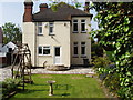
Edwardian House - rear garden
Many of the houses on the Marine Estate, Leigh-on-Sea, were built between 1900 and 1920 - some as homes for returning soldiers from the First World War. The houses are threatened with conversion into flats or, at worse, demolition. In their place? Flats.
Image: © David Williams
Taken: 14 May 2004
0.09 miles
2
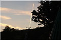
View of a vapour trail looking as if it is coming out of the chimney of a house on Marine Parade
Looking north-northwest.
Image: © Robert Lamb
Taken: 17 Jun 2017
0.11 miles
3
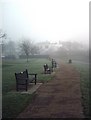
Belton Gardens, Leigh
With most of the country under a veil of freezing fog, Leigh proves no exception. No bums on the plentiful seats along the cliff-top walk.
Image: © John Myers
Taken: 22 Dec 2006
0.14 miles
4
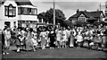
The Southend Carnival participants in 1963
The year is correct but the day & month are approximate.
Image: © Antony Ewart Smith
Taken: 21 Jul 1963
0.16 miles
5
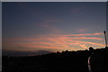
View of the sunset over Belton Bridge #3
Looking north-northwest.
Image: © Robert Lamb
Taken: 17 Jun 2017
0.16 miles
6
DK Shop, Leigh
One of those peculiar wedge-shaped (flatiron) buildings fitted in at the cross roads. Art deco? 'chais pas! Shame to have to categorize it as a mere "building".
Image: © John Myers
Taken: 26 Nov 2006
0.17 miles
7
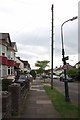
Westleigh Ave
Westleigh Ave is typical of the "between the wars" development that happened around Southend.
Image: © Glyn Baker
Taken: 20 May 2016
0.18 miles
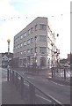
8
View of Eden Point and St Clement's Court on Rectory Grove and Broadway West from the High Street
Looking north. Eden Point (on the left) looks to have only been completed this year, as the Streetview from June 2014 shows it still in plastic sheeting: https://www.google.co.uk/maps/@51.5426901,0.6505821,3a,75y,157.83h,108.24t/data=!3m4!1e1!3m2!1sMgo9RZ5d2vWsgnssylg2dA!2e0.
Image: © Robert Lamb
Taken: 25 Oct 2014
0.19 miles
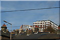
10

View of St Clement's Court, Broadway West from the High Street
Looking north-northeast.
Image: © Robert Lamb
Taken: 25 Oct 2014
0.19 miles