IMAGES TAKEN NEAR TO
Uttons Avenue, LEIGH-ON-SEA, SS9 2EL
Introduction
This page details the photographs taken nearby to Uttons Avenue, SS9 2EL by members of the Geograph project.
The Geograph project started in 2005 with the aim of publishing, organising and preserving representative images for every square kilometre of Great Britain, Ireland and the Isle of Man.

There are currently over 7.5m images from over14,400 individuals and you can help contribute to the project by visiting https://www.geograph.org.uk
Image Map
Images are licensed for reuse under creativecommons.org/licenses/by-sa/2.0
Notes
- Clicking on the map will re-center to the selected point.
- The higher the marker number, the further away the image location is from the centre of the postcode.
Image Listing (311 Images Found)
Images are licensed for reuse under creativecommons.org/licenses/by-sa/2.0
Image
Details
Distance
1
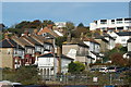
View of houses in Hadleigh Road from the old town
Looking north-northeast.
Image: © Robert Lamb
Taken: 25 Oct 2014
0.02 miles
2
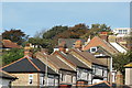
View of houses on Hadleigh Road from the old town #2
Looking north-northeast.
Image: © Robert Lamb
Taken: 25 Oct 2014
0.03 miles
3
View up Uttons Avenue from the seaside walkway
Looking north across the railway line and New Road.
Image: © Robert Lamb
Taken: 25 Oct 2014
0.05 miles
4
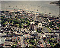
Aerial view of Southend seafront: Leigh cockle sheds and Rectory Grove
The buildings along the seafront comprise Old Leigh. Many of these on the seaward side are part of the famous Leigh Cockle-gathering industry. The road running left-to right is Rectory Grove. The road running from Rectory Grove, just below left of centre, is the beginning of Leigh Broadway. The green at the top right is the eastern tip of Two-Tree Island Image
The previous (eastern) photo in this sequence is Image This is the last photo in this sequence.
Image: © Edward Clack
Taken: 26 May 1988
0.05 miles
5
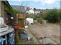
Outside The Old Foundry, Leigh-on-Sea
The full title is the Lynn Tait Gallery at the Old Foundry. This is the yard outside. See http://www.thelynntaitgallery.com/about-us.asp for more information.
The railway line is just beyond, and beyond that the cottages climb up the hill. Many houses were demolished when the railway was constructed in 1855.
Image: © Marathon
Taken: 21 Aug 2016
0.05 miles
6
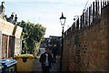
View of a cobbled walkway at the back of the shops on the High Street
Looking north-northeast.
Image: © Robert Lamb
Taken: 25 Oct 2014
0.06 miles
7
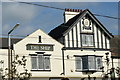
View of The Ship Hotel from the High Street
Looking north-northeast.
Image: © Robert Lamb
Taken: 25 Oct 2014
0.06 miles
8
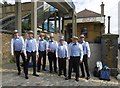
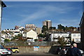
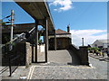
Barbershop singers in front of the original Leigh-on-Sea station
The barbershop singers were performing for the 2016 Leigh-on-Sea Maritime Festival.
Behind was the original Leigh-on-Sea station, opened on 1st July 1855 and closed on 1st January 1934 when it was replaced by the present station further to the west. The original building was then used by a local Sea Scout troop until the northern platform buildings were demolished to allow the widening of the adjacent road. The other platform and station building still exist and are currently used by Leigh-on-Sea Sailing Club as seen here.
Image: © Marathon
Taken: 21 Aug 2016
0.06 miles
9
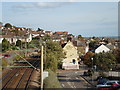
The original Leigh-on-Sea station
This was the original Leigh-on-Sea station, opened on 1st July 1855 and closed on 1st January 1934 when it was replaced by the present station further to the west. The original building was then used by a local Sea Scout troop until the northern platform buildings were demolished to allow the widening of the adjacent road. The other platform and station building still exist and are currently used by Leigh-on-Sea Sailing Club as seen here.
See also http://www.geograph.org.uk/photo/5084971
Image: © Marathon
Taken: 21 Aug 2016
0.06 miles
10
c2c railway through Old Leigh
Southend bound from Leigh Station
Image: © John Myers
Taken: 4 Oct 2009
0.06 miles