IMAGES TAKEN NEAR TO
Hillside Road, LEIGH-ON-SEA, SS9 2DT
Introduction
This page details the photographs taken nearby to Hillside Road, SS9 2DT by members of the Geograph project.
The Geograph project started in 2005 with the aim of publishing, organising and preserving representative images for every square kilometre of Great Britain, Ireland and the Isle of Man.

There are currently over 7.5m images from over14,400 individuals and you can help contribute to the project by visiting https://www.geograph.org.uk
Image Map
Images are licensed for reuse under creativecommons.org/licenses/by-sa/2.0
Notes
- Clicking on the map will re-center to the selected point.
- The higher the marker number, the further away the image location is from the centre of the postcode.
Image Listing (257 Images Found)
Images are licensed for reuse under creativecommons.org/licenses/by-sa/2.0
Image
Details
Distance
1
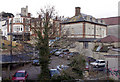
Old Leigh
Taken from the railway footbridge that replaced a level crossing about fifty years ago. The building in the foreground (which I have been told was once a hotel) has lain in a state of virtual dereliction since the 1950s and maybe longer.
Image: © David Kemp
Taken: 27 Oct 2008
0.02 miles
2
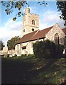
St. Clement's, Leigh
View from St.Clement's Court
Image: © John Myers
Taken: 26 Nov 2006
0.04 miles
3
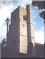
St. Clement's, Leigh - Tower
The tower of St. Clement's, Leigh. Unusual in that it has a stair-turret which also supports the flagpole atop the 80 ft tower.
Image: © John Myers
Taken: 11 Nov 2006
0.04 miles
4
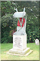
Dunkirk memorial, Leigh-on-Sea
Memorial to the fishermen of Leigh in St Clements churchyard, recording their efforts in rescuing British soldiers stranded on the beaches of Dunkirk.
Image: © Jim Osley
Taken: 1 Jul 2010
0.05 miles
5
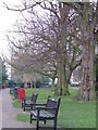
Leigh Library Gardens
These benches were nicer than the bird poo one.
Image
Image: © Julieanne Savage
Taken: 7 Jan 2007
0.05 miles
6
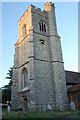
The tower of St Clements Church, Leigh-on-Sea
Image: © Trevor Harris
Taken: 1 Aug 2008
0.05 miles
7
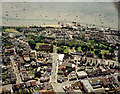
Aerial view of Southend seafront: Leigh seafront and town centre
The buildings along the seafront to the right are part of Old Leigh. The church just left of centre is that of St Clement. It lies on Leigh Broadway, which runs to the left and right. The road running from the church to the bottom centre is Elm Road, which continues to the A13 (London Road).
The previous (eastern) photo in this sequence is Image The next (western) photo is Image
Image: © Edward Clack
Taken: 26 May 1988
0.05 miles
8
Leigh-on-Sea
Looking down towards old Leigh-on-Sea with Canvey Island on the horizon. The Thames Estuary looking its best.
Image: © Adrian Benn
Taken: 19 May 2007
0.06 miles
9
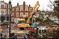
Site of former Bell Hotel, Old Leigh
The Bell Hotel stood derelict since the 1950s: that is, until the last week of November 2015 when it began quite literally to collapse. By then it had become a dangerous structure which needed to be completely demolished. By the time this picture was taken the demolition process was well underway. See Image for how the site looked in 2008.
Image: © David Kemp
Taken: 1 Dec 2015
0.06 miles
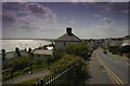
10
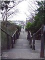
Leigh Steps
A grey January sea is behind those houses at the bottom!!
Image: © Julieanne Savage
Taken: 7 Jan 2007
0.06 miles