IMAGES TAKEN NEAR TO
Link Road, CANVEY ISLAND, SS8 9LA
Introduction
This page details the photographs taken nearby to Link Road, SS8 9LA by members of the Geograph project.
The Geograph project started in 2005 with the aim of publishing, organising and preserving representative images for every square kilometre of Great Britain, Ireland and the Isle of Man.

There are currently over 7.5m images from over14,400 individuals and you can help contribute to the project by visiting https://www.geograph.org.uk
Image Map
Images are licensed for reuse under creativecommons.org/licenses/by-sa/2.0
Notes
- Clicking on the map will re-center to the selected point.
- The higher the marker number, the further away the image location is from the centre of the postcode.
Image Listing (5 Images Found)
Images are licensed for reuse under creativecommons.org/licenses/by-sa/2.0
Image
Details
Distance
1
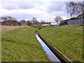
Drain, Canvey Island
One of several drains threading through the housing development on the island.
Image: © Robin Webster
Taken: 21 Feb 2015
0.17 miles
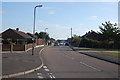
2
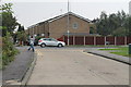
First avenue towards Link Road, Canvey Island
Image: © J.Hannan-Briggs
Taken: 4 Sep 2014
0.18 miles
3
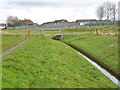
Drain, Canvey Island
One of several drains threading through and around the housing development on the island.
Image: © Robin Webster
Taken: 21 Feb 2015
0.20 miles
4
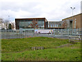
Cornelius Vermuyden School, Canvey Island
Named after the 17th century Dutch sea defence and drainage expert, who played a part in securing Canvey Island from the sea.
Image: © Robin Webster
Taken: 21 Feb 2015
0.21 miles
5
Maple Way, Canvey
Taken from the corner of Aspen Close.
Image: © Trevor Harris
Taken: 14 Oct 2011
0.22 miles