
IMAGES TAKEN NEAR TO
Kings Park, Creek Road, CANVEY ISLAND, SS8 8QU
Introduction
This page details the photographs taken nearby to Kings Park, Creek Road, SS8 8QU by members of the Geograph project.
The Geograph project started in 2005 with the aim of publishing, organising and preserving representative images for every square kilometre of Great Britain, Ireland and the Isle of Man.

There are currently over 7.5m images from over14,400 individuals and you can help contribute to the project by visiting https://www.geograph.org.uk
Image Map
Images are licensed for reuse under creativecommons.org/licenses/by-sa/2.0
Notes
- Clicking on the map will re-center to the selected point.
- The higher the marker number, the further away the image location is from the centre of the postcode.
Image Listing (5 Images Found)
Images are licensed for reuse under creativecommons.org/licenses/by-sa/2.0
Image
Details
Distance
1
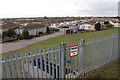
"Mobile" Homes
The Kings Park Residential Village. Demountable housing units.
Image: © John Myers
Taken: 15 Feb 2012
0.21 miles
3
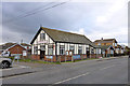
The Salvation Army, Canvey Island
On the corner of Mitchells Avenue and Barnards Avenue.
Image: © Robin Webster
Taken: 21 Feb 2015
0.24 miles
4
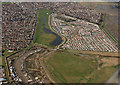
Kings Park Village
Canvey Height Country Park is bottom right. Above that is Kings Park Village.
Image: © terry joyce
Taken: 6 Mar 2009
0.24 miles
5
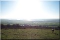
Canvey Island seen from Hadleigh Country Park
The sun shining over Canvey Leigh Beck and reflecting off the waters of Benfleet Creek on a bright winter's day.
Image: © Dave Playfair
Taken: 25 Jan 2004
0.24 miles