IMAGES TAKEN NEAR TO
Venlo Road, CANVEY ISLAND, SS8 8DH
Introduction
This page details the photographs taken nearby to Venlo Road, SS8 8DH by members of the Geograph project.
The Geograph project started in 2005 with the aim of publishing, organising and preserving representative images for every square kilometre of Great Britain, Ireland and the Isle of Man.

There are currently over 7.5m images from over14,400 individuals and you can help contribute to the project by visiting https://www.geograph.org.uk
Image Map
Images are licensed for reuse under creativecommons.org/licenses/by-sa/2.0
Notes
- Clicking on the map will re-center to the selected point.
- The higher the marker number, the further away the image location is from the centre of the postcode.
Image Listing (8 Images Found)
Images are licensed for reuse under creativecommons.org/licenses/by-sa/2.0
Image
Details
Distance
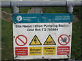
2
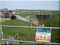
Hilton Road pumping station
On the north side of Somnes Avenue.
Image: © Ron Galliers
Taken: 17 Mar 2009
0.07 miles
3
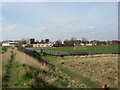
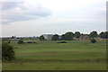
Castle View School
Seen from the golf course.
Image: © Ron Galliers
Taken: 17 Mar 2009
0.13 miles
4
Hilton Dyke, Canvey Island
Taken from Hilton Dyke weir. The channel seen here runs between Canvey Lake and Tewkes Creek Image
Image: © David Kemp
Taken: 11 Aug 2018
0.17 miles
5

Hilton Dyke Weir, Canvey Island
Taken looking across Canvey Lake towards the houses in Thisselt Road. Hilton Dyke is a flood control channel linking the lake itself and Tewkes Creek.
Image: © David Kemp
Taken: 11 Aug 2018
0.19 miles
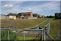
6
Castle Point golf club and Canvey Skills Campus
Image: © Robert Eva
Taken: 2 Jun 2017
0.19 miles
7
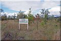
Creeky Wood
This new wood on Canvey Island was planted with many native species in 2008/9 with the help of local volunteers.
Image: © Glyn Baker
Taken: 9 Oct 2016
0.20 miles
8
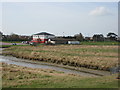
Canvey Rugby Club
Between Dovervelt Road and the sea wall.
Image: © Ron Galliers
Taken: 17 Mar 2009
0.22 miles