IMAGES TAKEN NEAR TO
Poplar Road, CANVEY ISLAND, SS8 7DZ
Introduction
This page details the photographs taken nearby to Poplar Road, SS8 7DZ by members of the Geograph project.
The Geograph project started in 2005 with the aim of publishing, organising and preserving representative images for every square kilometre of Great Britain, Ireland and the Isle of Man.

There are currently over 7.5m images from over14,400 individuals and you can help contribute to the project by visiting https://www.geograph.org.uk
Image Map
Images are licensed for reuse under creativecommons.org/licenses/by-sa/2.0
Notes
- Clicking on the map will re-center to the selected point.
- The higher the marker number, the further away the image location is from the centre of the postcode.
Image Listing (6 Images Found)
Images are licensed for reuse under creativecommons.org/licenses/by-sa/2.0
Image
Details
Distance
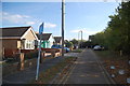
1
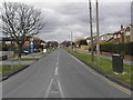
Furtherwick Road
Looking north towards Long Road.
Image: © Ron Galliers
Taken: 13 Feb 2005
0.08 miles
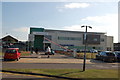
2
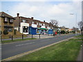
Supermarket Furtherwick Road
At the bottom (southern) end of Furtherwick Road near Labworth Green.
Image: © Ron Galliers
Taken: 22 Mar 2009
0.14 miles
3
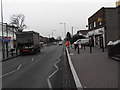
Furtherwick Road
Looking south towards Labworth Green and the river.
Image: © Ron Galliers
Taken: 13 Feb 2005
0.18 miles
4
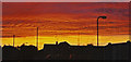
Sunset over Canvey Island
Luckily it was caused by the sun and not Coryton on fire!
Image: © Ron Galliers
Taken: Unknown
0.19 miles
5
Oak Road, Canvey
A no-through road with a model windmill at the end.
Image: © Trevor Harris
Taken: 14 Oct 2011
0.23 miles
6
Central Canvey Primary Care Centre
Viewed from outside the Paddocks.
Image: © Trevor Harris
Taken: 14 Oct 2011
0.24 miles