IMAGES TAKEN NEAR TO
Meynell Avenue, CANVEY ISLAND, SS8 7DA
Introduction
This page details the photographs taken nearby to Meynell Avenue, SS8 7DA by members of the Geograph project.
The Geograph project started in 2005 with the aim of publishing, organising and preserving representative images for every square kilometre of Great Britain, Ireland and the Isle of Man.

There are currently over 7.5m images from over14,400 individuals and you can help contribute to the project by visiting https://www.geograph.org.uk
Image Map
Images are licensed for reuse under creativecommons.org/licenses/by-sa/2.0
Notes
- Clicking on the map will re-center to the selected point.
- The higher the marker number, the further away the image location is from the centre of the postcode.
Image Listing (42 Images Found)
Images are licensed for reuse under creativecommons.org/licenses/by-sa/2.0
Image
Details
Distance
1
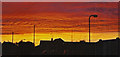
Sunset over Canvey Island
Luckily it was caused by the sun and not Coryton on fire!
Image: © Ron Galliers
Taken: Unknown
0.10 miles
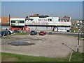
3
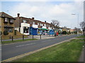
Supermarket Furtherwick Road
At the bottom (southern) end of Furtherwick Road near Labworth Green.
Image: © Ron Galliers
Taken: 22 Mar 2009
0.16 miles
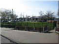
5
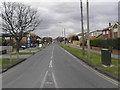
Furtherwick Road
Looking north towards Long Road.
Image: © Ron Galliers
Taken: 13 Feb 2005
0.17 miles
6
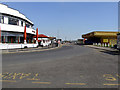
Canvey Island strip
Not quite Vegas, or even Southend, but seems popular even in March.
Image: © william
Taken: 7 Mar 2009
0.18 miles
7
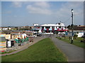
Canvey Island seafront
View along Eastern Esplanade with the Monico on the left. This area has many amusements.
Image: © Julieanne Savage
Taken: 9 Apr 2008
0.20 miles
8
The Monico Canvey Island
Run by a dedicated West Ham supporter (and he knows the other one too!)
Image: © Ron Galliers
Taken: 22 Mar 2009
0.20 miles
9
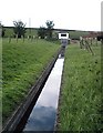
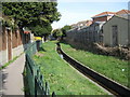
May Avenue, Canvey Island - Drain and pumping station
Concrete lined drain by the side of May Avenue. The pumping station is the white building beneath the sea wall.
Image: © John Myers
Taken: 24 Sep 2006
0.20 miles
10
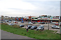
Canvey Island: Las Vegas Casino
The Ordnance Survey showed this building as a "Casino" in their map of 1962, so it has probably been in use as such for about 50 years. An earlier edition from 1939 shows that there was a "Boating Pool" at the foot of the sea defence wall where the car park is now.
Image: © Nigel Cox
Taken: 8 Mar 2011
0.20 miles