
IMAGES TAKEN NEAR TO
Thames Road, CANVEY ISLAND, SS8 0HH
Introduction
This page details the photographs taken nearby to Thames Road, SS8 0HH by members of the Geograph project.
The Geograph project started in 2005 with the aim of publishing, organising and preserving representative images for every square kilometre of Great Britain, Ireland and the Isle of Man.

There are currently over 7.5m images from over14,400 individuals and you can help contribute to the project by visiting https://www.geograph.org.uk
Image Map
Images are licensed for reuse under creativecommons.org/licenses/by-sa/2.0
Notes
- Clicking on the map will re-center to the selected point.
- The higher the marker number, the further away the image location is from the centre of the postcode.
Image Listing (4 Images Found)
Images are licensed for reuse under creativecommons.org/licenses/by-sa/2.0
Image
Details
Distance
1
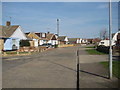
Hawkesbury Road
A fairly typical Canvey road.
Image: © Ron Galliers
Taken: 20 Mar 2009
0.04 miles
2

Time to go!
The fire brigade turn up at the front gates of the Calor Gas terminal. Probably a routine exercise as there were no blue lights or two-tones.
Image: © Ron Galliers
Taken: 20 Mar 2009
0.23 miles
3

Concord Rangers FC
On Haven Road, a Ryman League club.
Image: © Ron Galliers
Taken: 20 Mar 2009
0.24 miles
4
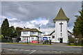
Catholic church, Canvey Island
The church of Our Lady of Canvey and English Martyrs. Who was the Lady of Canvey? Apparently it was the unofficial name of a navigation beacon on the island, otherwise known as the Stony or Deadman Beacon, which in outline crudely resembled a skirted woman. It used to be on the sea wall east of Deadman's Point, but is now gone. There cannot be many churches named after a navigation aid, although there are plenty of buoys etc. named after churches.
Image: © Robin Webster
Taken: 21 Feb 2015
0.24 miles