IMAGES TAKEN NEAR TO
St. Clements Close, BENFLEET, SS7 5XF
Introduction
This page details the photographs taken nearby to St. Clements Close, SS7 5XF by members of the Geograph project.
The Geograph project started in 2005 with the aim of publishing, organising and preserving representative images for every square kilometre of Great Britain, Ireland and the Isle of Man.

There are currently over 7.5m images from over14,400 individuals and you can help contribute to the project by visiting https://www.geograph.org.uk
Image Map
Images are licensed for reuse under creativecommons.org/licenses/by-sa/2.0
Notes
- Clicking on the map will re-center to the selected point.
- The higher the marker number, the further away the image location is from the centre of the postcode.
Image Listing (13 Images Found)
Images are licensed for reuse under creativecommons.org/licenses/by-sa/2.0
Image
Details
Distance
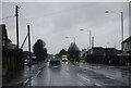
2
London Road (A13), South Benfleet
Towards Southend.
Image: © JThomas
Taken: 23 Aug 2022
0.13 miles
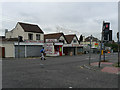
3
Crown Doors (closed down)
Showing a spectacular display of missing letters. The windows have tastefully arranged fly posters for a circus.
Image: © Robin Webster
Taken: 11 Sep 2016
0.15 miles
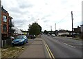
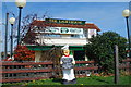
5
Junction of London Road and Kents Hill Rd, Benfleet
This junction offers a range of local shops. Visible here are a Chinese take-away, a locksmith and a small garden centre. London is off to the right.
Image: © John Rostron
Taken: 30 Sep 2009
0.16 miles
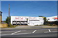
7
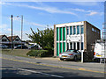
Benfleet Veterinary Surgery
This lies on Kents Hill Rd, just north of the junction with the A13 (London Rd).
Image: © John Rostron
Taken: 25 Sep 2009
0.17 miles
8
London Road (A13) and Kents Hill Road junction, New Thundersley
The A13 is one of the main roads between London and Southend. The main junction in the picture is Kents Hill Rd, where the bus is turning. The flat-topped building on the corner, to the left of the bus, was then a doctor's surgery and is now a veterinary surgery. The buildings above and below the junction (on the picture) are shops.
Image: © Edward Clack
Taken: 11 Sep 1987
0.17 miles
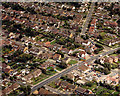
9
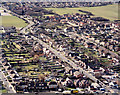
Kents Hill Road south of the A13 junction
This shows the housing just south of the A13 (London Road). The road running from the top left to the bottom right is Kents Hill Rd. To the right, just above centre is Holy Family Catholic Primary School. Just visible above it (and in the next grid square south) is Kents Hill Primary School. The fields at the top right are of The Appleton (comprehensive) School.
Image: © Edward Clack
Taken: Unknown
0.17 miles
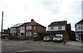
10
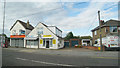
Closed Shops on London Road
Near cross roads junction of Kent's Hill Road.
Image: © Oast House Archive
Taken: 9 Sep 2010
0.19 miles