IMAGES TAKEN NEAR TO
Romsey Way, BENFLEET, SS7 5TT
Introduction
This page details the photographs taken nearby to Romsey Way, SS7 5TT by members of the Geograph project.
The Geograph project started in 2005 with the aim of publishing, organising and preserving representative images for every square kilometre of Great Britain, Ireland and the Isle of Man.

There are currently over 7.5m images from over14,400 individuals and you can help contribute to the project by visiting https://www.geograph.org.uk
Image Map
Images are licensed for reuse under creativecommons.org/licenses/by-sa/2.0
Notes
- Clicking on the map will re-center to the selected point.
- The higher the marker number, the further away the image location is from the centre of the postcode.
Image Listing (21 Images Found)
Images are licensed for reuse under creativecommons.org/licenses/by-sa/2.0
Image
Details
Distance
1
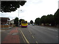
Bus stop and shelter on London Road, South Benfleet
Image: © JThomas
Taken: 23 Aug 2022
0.13 miles
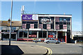
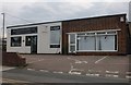
3
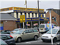
Big Al's Furniture Kingdom
Big Al Harrison's Furniture Kingdom is as much a local landmark as the Tarpot (Harvester) pub nearby. It probably is not quite so conspicuous now since the Tesco express (left of picture) was built between the shop and the road junction.
Image: © John Rostron
Taken: 7 Oct 2009
0.13 miles
4
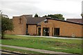
Holy Family Church, Tarpots, Benfleet
Image: © Trevor Harris
Taken: 26 Aug 2008
0.14 miles
5
Rileys, Tarpots
'Your home of sport'.
Image: © Robin Webster
Taken: 11 Sep 2016
0.15 miles
6
London Road, Thundersley
Been there done that. https://www.geograph.org.uk/photo/6550172
Image: © David Howard
Taken: 25 May 2021
0.18 miles
7
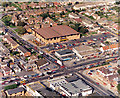
Aerial view of Great Tarpots from the west
The road across the lower centre is the A13 (London Road) and the one heading to the lower right is the B1006 (High Rd). The road heading to the upper right is Rushbottom Lane. To the lower right is the Harvester pub Image Above left of this is the row of shops Image The large, pale building at the centre was then known as Payless DIY, but is now a branch of Focus DIY.
Image: © Edward Clack
Taken: 18 Sep 1987
0.18 miles
8
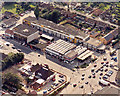
Great Tarpots from east south-east
This close-up aerial photo of the Tarpots junction shows the A13 (London Road) across the lower right and the B1006 (High road) towards the left centre. The Harvester pub Image is to the lower left, and Al Harrison's Furniture Kingdom Image stretches along the upper right of centre.
Image: © Edward Clack
Taken: 18 Sep 1987
0.18 miles
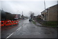
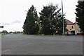
10
MSB Accountants on Rushbottom Road, Thundersley
Image: © David Howard
Taken: 26 Jul 2020
0.18 miles