IMAGES TAKEN NEAR TO
Oakfield Road, BENFLEET, SS7 5NW
Introduction
This page details the photographs taken nearby to Oakfield Road, SS7 5NW by members of the Geograph project.
The Geograph project started in 2005 with the aim of publishing, organising and preserving representative images for every square kilometre of Great Britain, Ireland and the Isle of Man.

There are currently over 7.5m images from over14,400 individuals and you can help contribute to the project by visiting https://www.geograph.org.uk
Image Map
Images are licensed for reuse under creativecommons.org/licenses/by-sa/2.0
Notes
- Clicking on the map will re-center to the selected point.
- The higher the marker number, the further away the image location is from the centre of the postcode.
Image Listing (3 Images Found)
Images are licensed for reuse under creativecommons.org/licenses/by-sa/2.0
Image
Details
Distance
1
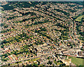
Aerial view of Benfleet High Rd at the Kents Hill junction
The High Road runs slightly upwards from the bottom left. Near the lower right, two roads join this. Kents Hill Road runs towards the upper left and Constitution Hill curves towards the centre. The road to the right of these is Thundersley Park Road. Most of the buildings along the High Road near the junction are shops Image That at the corner of Thundersley Park Road is South Benfleet Dental Surgery Image
Image: © Edward Clack
Taken: 1 Jul 1987
0.16 miles
2
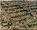
Aerial view of Benfleet cemetery corner, looking north-west
Cemetery Corner is the bend in the Benfleet High Road which here runs from the upper left to the lower right. The cemetery can clearly be seen to the left of the bend. The road running to the lower left from the corner is Jotman's Lane. That running to the lower centre is Benfleet Park Road. The group of houses on the curve, below the High Road on the right were, at the time, some of the few council houses in the area.
Image: © Edward Clack
Taken: 1 Jul 1987
0.19 miles
3
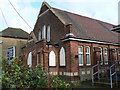
Benfleet Baptist Church
This lies at the south end of Kents Hill Road, just off the Benfleet High Road
Image: © John Rostron
Taken: 30 Nov 2009
0.24 miles