IMAGES TAKEN NEAR TO
Moreland Avenue, BENFLEET, SS7 4JW
Introduction
This page details the photographs taken nearby to Moreland Avenue, SS7 4JW by members of the Geograph project.
The Geograph project started in 2005 with the aim of publishing, organising and preserving representative images for every square kilometre of Great Britain, Ireland and the Isle of Man.

There are currently over 7.5m images from over14,400 individuals and you can help contribute to the project by visiting https://www.geograph.org.uk
Image Map
Images are licensed for reuse under creativecommons.org/licenses/by-sa/2.0
Notes
- Clicking on the map will re-center to the selected point.
- The higher the marker number, the further away the image location is from the centre of the postcode.
Image Listing (14 Images Found)
Images are licensed for reuse under creativecommons.org/licenses/by-sa/2.0
Image
Details
Distance
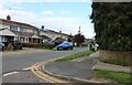
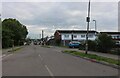
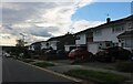
4
Seamore Avenue at the end of Eversley Road
Image: © David Howard
Taken: 25 May 2021
0.13 miles
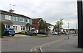
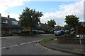
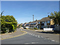
5
Eversley Road, Thundersley
A lot has changed since this was put online in 2012, a large conifer on the right has gone, and the little blue house at the end of the lower houses has appeared despite there being no gap between the houses either side in 2012. The fence on the right is also new.
Image: © David Howard
Taken: 25 May 2021
0.13 miles
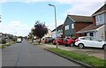
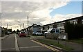
8
Houses on Seamore Avenue, New Thundersley
Image: © Robin Webster
Taken: 11 Sep 2016
0.18 miles