IMAGES TAKEN NEAR TO
Hart Road, BENFLEET, SS7 3UG
Introduction
This page details the photographs taken nearby to Hart Road, SS7 3UG by members of the Geograph project.
The Geograph project started in 2005 with the aim of publishing, organising and preserving representative images for every square kilometre of Great Britain, Ireland and the Isle of Man.

There are currently over 7.5m images from over14,400 individuals and you can help contribute to the project by visiting https://www.geograph.org.uk
Image Map
Images are licensed for reuse under creativecommons.org/licenses/by-sa/2.0
Notes
- Clicking on the map will re-center to the selected point.
- The higher the marker number, the further away the image location is from the centre of the postcode.
Image Listing (11 Images Found)
Images are licensed for reuse under creativecommons.org/licenses/by-sa/2.0
Image
Details
Distance
1
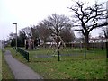
Not Playtime in Thundersley!
This children’s playground is situated in Hart Road Thundersley. A mobile home park can be seen in the background.
Image: © Glyn Baker
Taken: 15 Jan 2006
0.08 miles
2
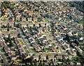
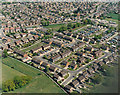
Aerial view of Hart Road and Woodlow, Thundersley
The Hart Road runs from the upper left to the centre-right of the image. Woodlow is the road running from the Hart Road, approximately half way (in the image) to the left and then (near the left) bending towards the lower-centre, and back to the right.
Image: © Edward Clack
Taken: 18 Sep 1987
0.09 miles
4
Aerial view of Meadow Close and part of Common Lane, Thundersley
Common Lane runs from the top left down to the centre right. Meadow Close is the cul-de-sac just below the centre. The road in the lower left is Woodlow and that in the upper right is Keysland. The area is typical suburbia.
Image: © Edward Clack
Taken: 18 Sep 1987
0.15 miles
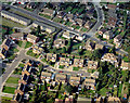
5
Aerial view of the Hart Road and the Rundels Caravan Park, Benfleet
The Hart Road bends from just above centre-left to top right, where it meets the Rayleigh Road at the Woodman's junction. The Rundels is the road winding around three sides of the houses in the centre. To the right of this is the Rundels Caravan Park. The fields at the lower left are part of Dark Lane School. Cedar Hall School lies to the upper right of the caravan park.
Image: © Edward Clack
Taken: 8 May 1987
0.16 miles
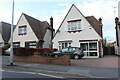
6
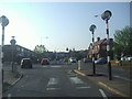
Ocean fish bar on Hart Road, Thundersley
Image: © David Howard
Taken: 25 May 2021
0.17 miles
7
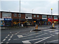
Shops on Rayleigh Road
A row of local shops on the A129 in Thundersley.
Image: © John Allan
Taken: 13 Feb 2012
0.19 miles
8
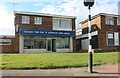
The junction of Rayleigh Road and Hart Road
Image: © David Howard
Taken: 24 May 2012
0.21 miles
9
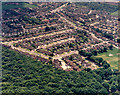
Aerial view of the ?Racecourse Estate? and Thundersley Common
The woods at the bottom of the picture are part of Thundersley Common. The housing
at the centre of the picture is known as the ‘Racecourse Estate’. The roads running from left to right, and slightly upwards beginning left-centre, are Sandown Road, Newton Park Road and Lewes Way. The road from centre-left running along the woodland edge is Cheltenham Drive. Common Lane runs from near the top centre to the mid-right.
Image: © Edward Clack
Taken: 5 Jun 1987
0.23 miles
10
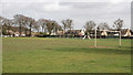
Recreation Ground
This is the Recreation Ground next to Thundersley Great Common.
Photo taken from Common Lane.
Image: © terry joyce
Taken: 1 Apr 2008
0.24 miles