IMAGES TAKEN NEAR TO
Princes Avenue, BENFLEET, SS7 3AZ
Introduction
This page details the photographs taken nearby to Princes Avenue, SS7 3AZ by members of the Geograph project.
The Geograph project started in 2005 with the aim of publishing, organising and preserving representative images for every square kilometre of Great Britain, Ireland and the Isle of Man.

There are currently over 7.5m images from over14,400 individuals and you can help contribute to the project by visiting https://www.geograph.org.uk
Image Map
Images are licensed for reuse under creativecommons.org/licenses/by-sa/2.0
Notes
- Clicking on the map will re-center to the selected point.
- The higher the marker number, the further away the image location is from the centre of the postcode.
Image Listing (11 Images Found)
Images are licensed for reuse under creativecommons.org/licenses/by-sa/2.0
Image
Details
Distance
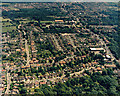
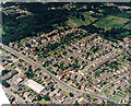
2
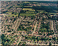
Aerial view of Kenneth Road and southern Thundersley
Kenneth Road runs from left to right in the lower third. Below and right of this is Thundersley Grove. The three roads above Kenneth Road are (from the left) Kings Park, The Chase and Dorothy Gardens. The buildings and fields just above centre -left are Thundersley Infants and Junior School (commonly known as Dark Lane School).
Image: © Edward Clack
Taken: 1 Jul 1987
0.11 miles
3
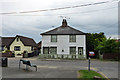
Cottages, Hart Road, Thundersley
One of the few older buildings in this area. Grade II listed, 18th/19th century.
Image: © Robin Webster
Taken: 28 May 2017
0.13 miles
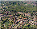
4
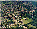
Aerial view of Kingston School and southern Thundersley
This view is almost of the same area as Image, but from the opposite direction. Kingston Primary School lies lower-centre, with the Church Road to its left. The white-roofed building just below-left of centre is the postal sorting office. The wood to the right is Coombe Wood. For other roads and buildings see Image
Image: © Edward Clack
Taken: 1 Jul 1987
0.16 miles
6
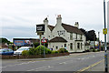
The White Hart, Thundersley
On Hart Road.
Image: © Robin Webster
Taken: 28 May 2017
0.17 miles
7
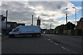
Parking area on Church Road, Thundersley
The post office is on the left.
Image: © David Howard
Taken: 25 May 2021
0.19 miles
8
Aerial view of Kenneth Road and southern Thundersley
This view is of the area just south of Image The two parallel roads at the bottom are Thundersley grove (lower) and Kenneth Road. The road at the lower left is Coombewood Drive. The road along the centre-left is The Chase. The road from lower-right to upper centre is the A13 (Kiln Rd). The larger flat-roofed building at the Kiln Road - Kenneth Road junction is Hobson's clothing factory. The smaller flat-roofed building just below it was the offices of the local Social Services. This has recently been demolished. The red-roofed building just below top-centre is Runnymede Hall. The larger, grey-roofed buildings below it are South-East Essex Sixth-form College (now SEEVIC College).
Image: © Edward Clack
Taken: 1 Jul 1987
0.22 miles
9
Aerial view of the Church Road - Hart Road junction, Thundersley
Church Road runs from centre-left to the lower centre. From the mini-roundabout, it continues as Hart Road to the lower right. The other road leading from the mini-roundabout to the bottom is Kenneth Road. The roads from the Church/Hart Road leading upper right are (from the left) Grasmere road, Borrowdale Road (with Borrowdale Close leading from it) and Raymonds Drive. The long white-roofed building in the lower right is the postal sorting office. The building to the right of this, at the Kenneth Road - Church Road junction is a clinic. The white triangle at the lower left is the aircraft wing.
Image: © Edward Clack
Taken: 1 Jul 1987
0.22 miles
10
Aerial view of Kenneth Road and Coombe Wood, Benfleet
Kenneth Road runs from the centre-left to the lower right. The road running to the lower centre is The Chase. The road above and parallel to Kenneth Road is Thundersley Grove. Coombe Wood lies above this.
Image: © Edward Clack
Taken: 8 May 1987
0.23 miles