
IMAGES TAKEN NEAR TO
Bramble Crescent, BENFLEET, SS7 2UZ
Introduction
This page details the photographs taken nearby to Bramble Crescent, SS7 2UZ by members of the Geograph project.
The Geograph project started in 2005 with the aim of publishing, organising and preserving representative images for every square kilometre of Great Britain, Ireland and the Isle of Man.

There are currently over 7.5m images from over14,400 individuals and you can help contribute to the project by visiting https://www.geograph.org.uk
Image Map
Images are licensed for reuse under creativecommons.org/licenses/by-sa/2.0
Notes
- Clicking on the map will re-center to the selected point.
- The higher the marker number, the further away the image location is from the centre of the postcode.
Image Listing (8 Images Found)
Images are licensed for reuse under creativecommons.org/licenses/by-sa/2.0
Image
Details
Distance
1
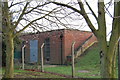
Reservoir valve house
Bramble road reservoirs
Image: © John Myers
Taken: 28 Dec 2009
0.07 miles
2
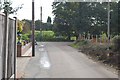
The End of Bramble Lane
Bramble Lane, Daws Heath, ends at this junction with Bramble Crescent (dead end in both directions).
Image: © Trevor Harris
Taken: 3 Oct 2008
0.11 miles
3
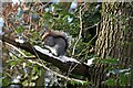
Grey squirrel snacking by Poors Lane North
The roadside verges on this section of Poors Lane are managed by Essex County Council for the benefit of wildlife. This squirrel doesn't need a second invitation - though it seems to have chosen a chilly seat.
Image: © Trevor Harris
Taken: 10 Feb 2021
0.11 miles
4

Bramble Lane
This shows Bramble Lane at its junction with an unmade road to the left. Bramble Lodge stands on the corner.
Image: © Trevor Harris
Taken: 3 Oct 2008
0.16 miles
5
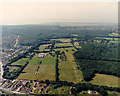
Aerial view of Garrolds Farm and part of Pound Wood
Garrolds Farm occupies much of the centre of this photo. The farm buildings are just left of centre. The wood to the right is Pound Wood Nature Reserve http://www.poundwood.org.uk/ , owned and managed by the Essex Wildlife Trust http://www.essexwt.org.uk/. Image shows a closer view of the corner of the wood.
The woodland in the middle distance is Belfairs Nature Reserve. The road across the bottom left corner is the A127 (London to Southend Arterial Road). The minor road just visible and running across the bottom is the Eastwood Old Road.
Image: © Edward Clack
Taken: 3 Aug 1987
0.19 miles
6
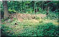
Brash pile in Pound Wood nature reserve, Benfleet
Brash is the small wood and twigs left over after coppicing. It is often burned, but a better use is to heap it up into a pile, as here. It gradually rots down, and provides a food source for many organisms, including invertebrates that form food for other woodland animals, especially birds. It can also provide a good hibernation site for hedgehogs. This brash pile is at least two years old.
Pound Wood http://www.poundwood.org.uk is owned and managed by the Essex Wildlife Trust http://www.essexwt.org.uk .
Image: © John Rostron
Taken: 15 May 1999
0.24 miles
7
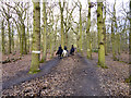
Horse riding in Belfairs Great Wood
The white rings on the trees appear to mark the official bridleway.
Image: © Robin Webster
Taken: 28 Feb 2016
0.25 miles
8
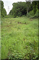
Power line corridor in Pound Wood nature reserve, Benfleet
This was taken from near the western end of the corridor (though still within TQ8288). The pylon in the distance is seen closer to in Image The coppice regrowth seen there had been cut back the previous winter.
The electricity utility has a duty to maintain clearance on either side of its power lines. This ensures that there is a permanent glade through the wood. The management tries to maintain this as a short-rotation coppice so that the foliage does not encroach onto the power lines. This regime also permanently maintains the conditions favourable to Cow-wheat, the food plant of the Heath Fritillary butterfly. This Fritillary has subsequently been introduced into Pound Wood at this point.
Image: © John Rostron
Taken: 15 Jun 2000
0.25 miles