IMAGES TAKEN NEAR TO
Woodfield Road, BENFLEET, SS7 2ET
Introduction
This page details the photographs taken nearby to Woodfield Road, SS7 2ET by members of the Geograph project.
The Geograph project started in 2005 with the aim of publishing, organising and preserving representative images for every square kilometre of Great Britain, Ireland and the Isle of Man.

There are currently over 7.5m images from over14,400 individuals and you can help contribute to the project by visiting https://www.geograph.org.uk
Image Map
Images are licensed for reuse under creativecommons.org/licenses/by-sa/2.0
Notes
- Clicking on the map will re-center to the selected point.
- The higher the marker number, the further away the image location is from the centre of the postcode.
Image Listing (5 Images Found)
Images are licensed for reuse under creativecommons.org/licenses/by-sa/2.0
Image
Details
Distance
1
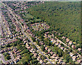
Aerial view of Scrub Lane and Belfairs Nature Reserve
Belfairs Nature Reserve occupies most of the upper right of the picture. Scrub lane runs from the upper left corner to the bottom centre.
Image: © Edward Clack
Taken: 8 May 1987
0.12 miles
2
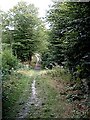
Valley track - Hadleigh Great Wood
Track running north-south through wood across the valley of a small tributary of Prittle Brook.
Image: © John Myers
Taken: 19 Aug 2006
0.23 miles
3
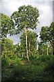
Great Wood Coppice
Hadleigh Great Wood has been managed by coppicing for hundreds of years http://www.wildessex.net/sites/Belfairs%20Park.htm
Image: © Glyn Baker
Taken: 28 Aug 2011
0.24 miles
4
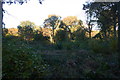
Great Wood, site of Forest Keeper's Hut
Despite featuring prominently on OS maps, the Forest Keeper's Hut seems to be no more. Its site would appear to be the land in the right foreground.
Image: © David Kemp
Taken: 9 Nov 2012
0.24 miles
5
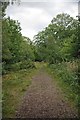
A Great Wood Path
A well maintained path through Hadleigh Great Wood http://www.visitsouthend.co.uk/Leigh-on-Sea-Belfairs-Park-and-Nature-Reserve/details/?dms=13&nearby=1&GroupId=2&venue=0670186
Image: © Glyn Baker
Taken: 28 Aug 2011
0.25 miles