
IMAGES TAKEN NEAR TO
Cherrymeade, BENFLEET, SS7 1UA
Introduction
This page details the photographs taken nearby to Cherrymeade, SS7 1UA by members of the Geograph project.
The Geograph project started in 2005 with the aim of publishing, organising and preserving representative images for every square kilometre of Great Britain, Ireland and the Isle of Man.

There are currently over 7.5m images from over14,400 individuals and you can help contribute to the project by visiting https://www.geograph.org.uk
Image Map
Images are licensed for reuse under creativecommons.org/licenses/by-sa/2.0
Notes
- Clicking on the map will re-center to the selected point.
- The higher the marker number, the further away the image location is from the centre of the postcode.
Image Listing (20 Images Found)
Images are licensed for reuse under creativecommons.org/licenses/by-sa/2.0
Image
Details
Distance
1
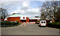
Seevic College
Seevic College is next to Castle Point Council Offices on the A13.
See http://www.seevic-college.ac.uk/seevic/main/index.php
Image: © terry joyce
Taken: 1 Apr 2008
0.07 miles
5
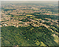
Aerial view of Thundersley Glen and Thundersley
Thundersley Glen is the woodland and open space in the lower half of the photo. The housing in the upper half is Thundersley. The buildings just visible above right of centre are the Runnymede Pool and Hall (Image). The woodlands just below the upper right are the Daws Heath woods.
Image: © Edward Clack
Taken: 1 Jul 1987
0.16 miles
8
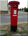
George V postbox on Bartley Road
Postbox No. SS7 233.
Image: © JThomas
Taken: 23 Aug 2022
0.18 miles
9
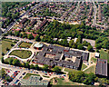
Aerial view of SEEVIC, Benfleet
At the time of this photo, in 1987, this was known as South-East Essex Sixth-form College, and given the acronym SEEVIC (VI for six). Today it has lost the sixth-form connotation, and bears the name of SEEVIC College. (See Image for an modern view.) The circular building at the upper left of the college is a theatre widely used for public events, as well as teaching. The road to the top left is the A13 (London Road). The building at the bottom is Runnymede Pool.
Image: © Edward Clack
Taken: 8 May 1987
0.18 miles
10
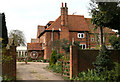
Thundersley Hall
The name plaque on this impressive looking house is Thundersley Hall.
Image: © terry joyce
Taken: 1 Apr 2008
0.18 miles