IMAGES TAKEN NEAR TO
Kiln Road, BENFLEET, SS7 1SH
Introduction
This page details the photographs taken nearby to Kiln Road, SS7 1SH by members of the Geograph project.
The Geograph project started in 2005 with the aim of publishing, organising and preserving representative images for every square kilometre of Great Britain, Ireland and the Isle of Man.

There are currently over 7.5m images from over14,400 individuals and you can help contribute to the project by visiting https://www.geograph.org.uk
Image Map
Images are licensed for reuse under creativecommons.org/licenses/by-sa/2.0
Notes
- Clicking on the map will re-center to the selected point.
- The higher the marker number, the further away the image location is from the centre of the postcode.
Image Listing (12 Images Found)
Images are licensed for reuse under creativecommons.org/licenses/by-sa/2.0
Image
Details
Distance
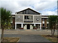
2
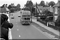
Kiln Road, Hadleigh – 1972
Southend Corporation bus services extended well beyond the borough boundary as part of a coordination agreement with Eastern National. Bus 354, a Daimler Fleetline with Northern Counties body, new in 1971, is returning to Southend from Rayleigh Station.
This is one of a series of views featuring buses in the 60s, 70s, and 80s. http://www.geograph.org.uk/search.php?i=137652761
Image: © Alan Murray-Rust
Taken: 24 Sep 1972
0.06 miles
5
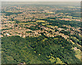
Aerial view of Thundersley Glen and Thundersley
Thundersley Glen is the woodland and open space in the lower half of the photo. The housing in the upper half is Thundersley. The buildings just visible above right of centre are the Runnymede Pool and Hall (Image). The woodlands just below the upper right are the Daws Heath woods.
Image: © Edward Clack
Taken: 1 Jul 1987
0.15 miles
7
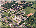
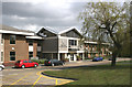
Aerial view of Castle Point Council Offices, Runnymede Hall and Pool
The Council Offices lie just below centre in this photo. In this 1987 photo they are surrounded by temporary buildings. Since then they have been extensively rebuilt and the temporary buildings removed (see Imagefor a 2008 view). Above right of the council offices are two buildings. The one with the grey-green roof is Runnymede Swimming Pool. The one with the brick-red roof is Runnymede Hall, used for a wide variety of functions. In the upper centre is SEEVIC (seen closer in Image). The road at the lower left is the A13 (Kiln Road).
Image: © Edward Clack
Taken: 3 Aug 1987
0.18 miles
8
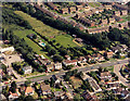
Aerial view of Kiln Road and Shipwrights Drive junction, Thundersley
Kiln Road runs across the bottom, with Shipwrights Drive joining it at the right. The land to the right, above the white house were then (1987) a nursery. This land, and the green area in the centre, is currently the subject of a planning application for 150 new houses. This, unsurprisingly, has been the subject of considerable local opposition.
Image: © Edward Clack
Taken: 3 Aug 1987
0.21 miles
10
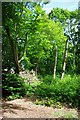
Coopers Wood
Coopers Wood is a five acre Essex Wildlife Thrust reserve on the edge of ImageThe land was bequeathed to The Trust in about 2003 by the Cooper family. There is no access to the reserve other than through the driveway of a private house. This means visiting is only possible by arrangement with the warden who may be contacted through the trust see http://www.essexwt.org.uk/ .. The reserve is managed with a “light touch” by a band of dedicated volunteers during their
Image To see the next reserve on a virtual tour of Essex Wildlife trust reserves go visit Image
Image: © Glyn Baker
Taken: 9 Jun 2010
0.22 miles