IMAGES TAKEN NEAR TO
London Road, BENFLEET, SS7 1BD
Introduction
This page details the photographs taken nearby to London Road, SS7 1BD by members of the Geograph project.
The Geograph project started in 2005 with the aim of publishing, organising and preserving representative images for every square kilometre of Great Britain, Ireland and the Isle of Man.

There are currently over 7.5m images from over14,400 individuals and you can help contribute to the project by visiting https://www.geograph.org.uk
Image Map
Images are licensed for reuse under creativecommons.org/licenses/by-sa/2.0
Notes
- Clicking on the map will re-center to the selected point.
- The higher the marker number, the further away the image location is from the centre of the postcode.
Image Listing (22 Images Found)
Images are licensed for reuse under creativecommons.org/licenses/by-sa/2.0
Image
Details
Distance
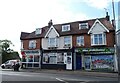
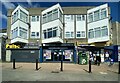
2
London Road (A13), Hadleigh
Towards Southend.
Image: © JThomas
Taken: 23 Aug 2022
0.04 miles
3
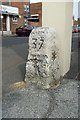
Old Milestone by the A13, London Road, Hadleigh parish
Carved stone post by the A13, in parish of HADLEIGH (CASTLE POINT District), at junction with Meadow Road, by wall in pavement, on North side of road. Erected by the Rochford Hundred (Div of Essex First Dist) turnpike trust in the 19th century.
Inscription reads:-
LONDON
37
SOUTHEND
1
Grade II listed.
List Entry Number: 1263835 https://historicengland.org.uk/listing/the-list/list-entry/1263835
Milestone Society National ID: EX_RYLE37.
Image: © JV Nicholls
Taken: Unknown
0.05 miles
5
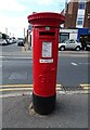
George V postbox on London Road, Hadleigh
Postbox No. SS7 216.
Image: © JThomas
Taken: 23 Aug 2022
0.06 miles
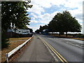
6
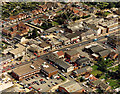
Aerial view of east Hadleigh, London Road
This shows the London Road east of the Hadleigh main centre. There are a number of shops, offices and light industry along this stretch.
Image: © Edward Clack
Taken: 11 Sep 1987
0.12 miles
7
View of the backs of houses on Tattersall Gardens from Hadleigh Castle
Looking south-southeast.
Image: © Robert Lamb
Taken: 23 Aug 2015
0.18 miles
9
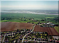
Aerial view of south Hadleigh and the Salvation Army Farm
The road leading from the bottom centre is Castle Lane, leading to the Salvation Army farm Image, visible right of centre. Beyond the farm are the Hadleigh Marshes, with the railway line crossing left to right. Beyond the creek is Canvey Island. The houses in the foreground are the southern part of the Hadleigh built-up area.
Image: © Edward Clack
Taken: 8 May 1987
0.18 miles
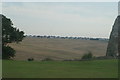
10
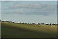
View of the A13 from Hadleigh Castle
Looking north-northeast.
Image: © Robert Lamb
Taken: 25 Oct 2014
0.19 miles