IMAGES TAKEN NEAR TO
Caversham Park Avenue, RAYLEIGH, SS6 9QA
Introduction
This page details the photographs taken nearby to Caversham Park Avenue, SS6 9QA by members of the Geograph project.
The Geograph project started in 2005 with the aim of publishing, organising and preserving representative images for every square kilometre of Great Britain, Ireland and the Isle of Man.

There are currently over 7.5m images from over14,400 individuals and you can help contribute to the project by visiting https://www.geograph.org.uk
Image Map
Images are licensed for reuse under creativecommons.org/licenses/by-sa/2.0
Notes
- Clicking on the map will re-center to the selected point.
- The higher the marker number, the further away the image location is from the centre of the postcode.
Image Listing (71 Images Found)
Images are licensed for reuse under creativecommons.org/licenses/by-sa/2.0
Image
Details
Distance
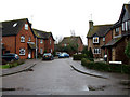
1
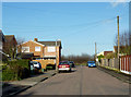
Caversham Park Avenue
This is a no through road accessed from Rawreth Lane.
Image: © terry joyce
Taken: 23 Nov 2012
0.04 miles
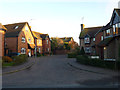
2
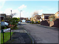
Mann's Way
This is a cul de sac reached from Rawreth Lane via Caversham Park Avenue.
Image: © terry joyce
Taken: 23 Nov 2012
0.05 miles
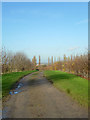
3
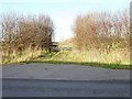
Entrance to Bridleway?
The question mark is because the track behind the gate on Lubard's Farm appears to be being used as a Bridleway but it does not appear to be designated as such on the map.
Image: © terry joyce
Taken: 23 Nov 2012
0.06 miles
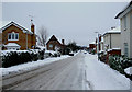
4
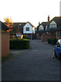
Farm View
This type of development seems to be the norm in Rayleigh, where they demolish one or more properties and build a small estate.
Image: © terry joyce
Taken: 14 Nov 2012
0.08 miles
5
Lincoln Way
This is one of the roads on a housing estate that is accessed from Downhall Park Way.
Image: © terry joyce
Taken: 12 Jan 2011
0.09 miles
6
Lincoln Way
This is part of a fairly large housing development that was built on the site of a nursery.
Image: © terry joyce
Taken: 14 Nov 2012
0.09 miles
7
Lubard's Track
This is one of the farm tracks on Lubard's Farm.
Image: © terry joyce
Taken: 23 Nov 2012
0.09 miles
8

End of the line
This is a parking area at the end of Norwich Crescent. The bulk of this centisquare is houses in Truro Crescent.
Image: © terry joyce
Taken: 27 Nov 2012
0.10 miles
9
Downhall Park Way
Image: © terry joyce
Taken: 3 Dec 2010
0.10 miles
10
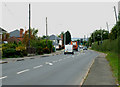
Rawreth Lane
A very busy road from the A1245 to the Hullbridge Road.
The traffic lights are at the junction of Downhall Park Way.
Image: © terry joyce
Taken: 21 Oct 2010
0.10 miles