IMAGES TAKEN NEAR TO
Cordelia Crescent, RAYLEIGH, SS6 9JJ
Introduction
This page details the photographs taken nearby to Cordelia Crescent, SS6 9JJ by members of the Geograph project.
The Geograph project started in 2005 with the aim of publishing, organising and preserving representative images for every square kilometre of Great Britain, Ireland and the Isle of Man.

There are currently over 7.5m images from over14,400 individuals and you can help contribute to the project by visiting https://www.geograph.org.uk
Image Map (Loading...)


Getting Data...Please wait
Leaflet Map data © OpenStreetMap
Images are licensed for reuse under creativecommons.org/licenses/by-sa/2.0
Notes
- Clicking on the map will re-center to the selected point.
- The higher the marker number, the further away the image location is from the centre of the postcode.
Image Listing (23 Images Found)
Images are licensed for reuse under creativecommons.org/licenses/by-sa/2.0
Image
Details
Distance
1
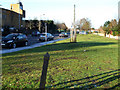
The A129 London Road
This is a section of the A129 London Road in Rayleigh, it allows traffic to enter and leave Rayleigh via the A1245. The post in the foreground is an Essex County Council Boundary Post. Its purpose is not known. There are around six of these in the vicinity. They are black on this side of the road and green on the other side.
Image: © terry joyce
Taken: 9 Jan 2011
0.05 miles
3
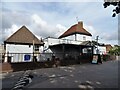
Travellers Joy, Rayleigh
Hungry Horse public house on Down Hall Road.
See Image] for sign.
Image: © JThomas
Taken: 25 Aug 2022
0.10 miles
4
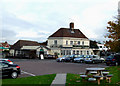
The Travellers Joy
This is a Hungry Horse Pub on the junction of the A129 and Down Hall Road.
Image: © terry joyce
Taken: 18 Oct 2010
0.10 miles
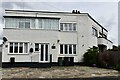
5
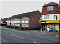
Down Hall Stores
A convenience store in Downhall Road.
Image: © terry joyce
Taken: 28 Oct 2010
0.10 miles
6
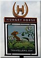
Sign for the Travellers Joy, Rayleigh
See Image] for public house.
Image: © JThomas
Taken: 25 Aug 2022
0.11 miles
7
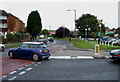
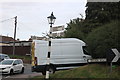
Busy Junction
This is the junction of Down Hall Road and the A129 London Road.
It gets extremely busy during peak times; especially if you want to turn right from Down Hall Road, like this Mini.
Image: © terry joyce
Taken: 28 Oct 2010
0.13 miles
8
Birch Close
As you can see this cul de sac is close to the Southend to London railway line.
If you were standing where I took the photo and turned round you would see Image
Image: © terry joyce
Taken: 28 Oct 2010
0.14 miles
9

Two Windmills
The grid reference is for the Wind Turbine.
I took the picture from Sweyne Park to show Rayleigh's two Windmills.
You can also see Holy Trinity Church in Rayleigh High Street.
Image: © terry joyce
Taken: 15 Oct 2007
0.15 miles
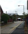
10
Fingerpost on Station Road, Rayleigh
This is the first one I've seen with a lamp on.
Image: © David Howard
Taken: 26 Jul 2020
0.15 miles