IMAGES TAKEN NEAR TO
Twin Oaks Walk, RAYLEIGH, SS6 9GJ
Introduction
This page details the photographs taken nearby to Twin Oaks Walk, SS6 9GJ by members of the Geograph project.
The Geograph project started in 2005 with the aim of publishing, organising and preserving representative images for every square kilometre of Great Britain, Ireland and the Isle of Man.

There are currently over 7.5m images from over14,400 individuals and you can help contribute to the project by visiting https://www.geograph.org.uk
Image Map (Loading...)


Getting Data...Please wait
Leaflet Map data © OpenStreetMap
Images are licensed for reuse under creativecommons.org/licenses/by-sa/2.0
Notes
- Clicking on the map will re-center to the selected point.
- The higher the marker number, the further away the image location is from the centre of the postcode.
Image Listing (50 Images Found)
Images are licensed for reuse under creativecommons.org/licenses/by-sa/2.0
Image
Details
Distance
1
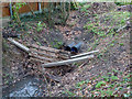
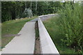
Underground Stream
There is where the stream that runs through Sweyne Park goes under a recent housing development adjacent to Victoria Avenue.
I believe the makeshift barrier is to prevent the pipes from becoming blocked and flooding the gardens.
Image: © terry joyce
Taken: 26 Dec 2011
0.01 miles
2
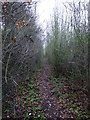
Unofficial Path
This unmade path is on the very West of Sweyne Park behind the houses in Victoria Avenue.
Image: © terry joyce
Taken: 26 Dec 2011
0.03 miles
3
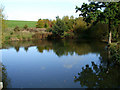
Sweyne Park Pond
Tranquility, till the dogs jump in, then all hells let loose.
Image: © terry joyce
Taken: 21 Oct 2010
0.05 miles
4
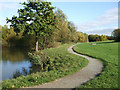
Sweyne Park Pond
The Pond in Sweyne Park is in the south west corner of the park.
The park has a bridleway running round its perimeter of about 1.25 miles.
Image: © terry joyce
Taken: 15 Oct 2007
0.05 miles
5
Path by the pond
This path by the pond in Sweyne Park leads to the entrance near Canterbury Close.
Image: © terry joyce
Taken: 21 Oct 2010
0.05 miles
6
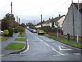
Cheapside West
This road leads to one of the entrances of Sweyne Park School.
Image: © terry joyce
Taken: 27 Oct 2010
0.06 miles
7
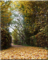
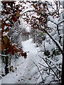
Carpet of leaves
This is part of the Sweyne Park Bridleway, close to the stream that runs from the pond.
Image: © terry joyce
Taken: 5 Nov 2010
0.06 miles
9
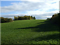
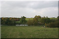
Uphill struggle
This is the view from the south side of the pond in Sweyne Park.
Image: © terry joyce
Taken: 21 Oct 2010
0.07 miles
10
Sweyne Park
This pathway bypasses a steep section of the Bridleway. It runs from near the stream to near the Victoria Avenue entrance.
Image: © terry joyce
Taken: 1 Dec 2010
0.07 miles