IMAGES TAKEN NEAR TO
Louis Drive, RAYLEIGH, SS6 9DY
Introduction
This page details the photographs taken nearby to Louis Drive, SS6 9DY by members of the Geograph project.
The Geograph project started in 2005 with the aim of publishing, organising and preserving representative images for every square kilometre of Great Britain, Ireland and the Isle of Man.

There are currently over 7.5m images from over14,400 individuals and you can help contribute to the project by visiting https://www.geograph.org.uk
Image Map
Images are licensed for reuse under creativecommons.org/licenses/by-sa/2.0
Notes
- Clicking on the map will re-center to the selected point.
- The higher the marker number, the further away the image location is from the centre of the postcode.
Image Listing (17 Images Found)
Images are licensed for reuse under creativecommons.org/licenses/by-sa/2.0
Image
Details
Distance
1
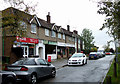
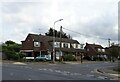
Parade of Shops
This small parade of shops is on a road parallel with the London Road, A129; however this road is also shown as the London Road.
Image: © terry joyce
Taken: 27 Oct 2010
0.09 miles
2
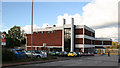
Eon Customer Contact Centre
Eon the company that runs Powergen has a Customer Contact Centre in this building on the London Road (A129) in Rayleigh.
Image: © terry joyce
Taken: 29 Oct 2007
0.11 miles
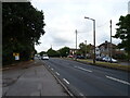
6
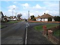
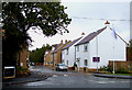
Louis Drive Rayleigh
This is Louis Drive (West) at the junction of Alexandria Drive, Louis Close is accessed between the houses on the right. This is on an estate bounded by the A129 in the north and the Southend Victoria to Shenfield Railway in the south
Image: © Glyn Baker
Taken: 21 Feb 2006
0.15 miles
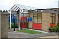
7
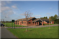
Grange Community Centre
The Grange Community Centre is in Little Wheatley Chase,Rayleigh.
There is a car park and access to Wheatley Wood is across the playing fields.
See Image
Image: © terry joyce
Taken: 2 Nov 2007
0.16 miles
8
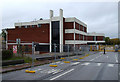
Eon's Gone
This building is now for sale (October 2010). It is currently being used by the Police for dog training purposes. It will probably be developed for housing.
Image: © terry joyce
Taken: 27 Oct 2010
0.16 miles
9
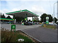
Service station on London Road, Rayleigh
Petrol 165.9p.
Diesel 185.9p.
Image: © JThomas
Taken: 25 Aug 2022
0.16 miles
10
The Barringtons
The name Barringtons was on the developers board. This recent development is typical in this area. The developer knocked down a single bungalow and has squeezed all these houses on the plot, unfortunately the local infrastructure is struggling to accommodate the amount of these developments. A new road has been created called Gunn Close.
Image: © terry joyce
Taken: 27 Oct 2010
0.17 miles