IMAGES TAKEN NEAR TO
Falcon Close, RAYLEIGH, SS6 9BH
Introduction
This page details the photographs taken nearby to Falcon Close, SS6 9BH by members of the Geograph project.
The Geograph project started in 2005 with the aim of publishing, organising and preserving representative images for every square kilometre of Great Britain, Ireland and the Isle of Man.

There are currently over 7.5m images from over14,400 individuals and you can help contribute to the project by visiting https://www.geograph.org.uk
Image Map (Loading...)


Getting Data...Please wait
Leaflet Map data © OpenStreetMap
Images are licensed for reuse under creativecommons.org/licenses/by-sa/2.0
Notes
- Clicking on the map will re-center to the selected point.
- The higher the marker number, the further away the image location is from the centre of the postcode.
Image Listing (6 Images Found)
Images are licensed for reuse under creativecommons.org/licenses/by-sa/2.0
Image
Details
Distance
1
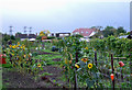
Kenilworth Gardens Allotment
Access to this Allotment is by the pathway that links Kenilworth Gardens with Station Avenue.
Image: © terry joyce
Taken: 19 Oct 2010
0.15 miles
2
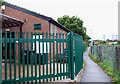
Scout Hut
This is the hut of the 1st Rayleigh Scouts. The pathway links Image with Station Avenue.
Image: © terry joyce
Taken: 19 Oct 2010
0.16 miles
3
Kenilworth Gardens
Pedestrians use this road to get to Station Avenue and beyond by a footpath.
Image: © terry joyce
Taken: 19 Oct 2010
0.23 miles
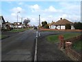
4
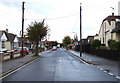
Louis Drive East, Rayleigh
The road running from left to right is the A129 London Road.
Image: © terry joyce
Taken: 27 Oct 2010
0.24 miles
5
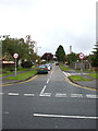
Louis Drive Rayleigh
This is Louis Drive (West) at the junction of Alexandria Drive, Louis Close is accessed between the houses on the right. This is on an estate bounded by the A129 in the north and the Southend Victoria to Shenfield Railway in the south
Image: © Glyn Baker
Taken: 21 Feb 2006
0.25 miles
6
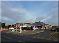
Tesco Express
Opened on 17th February 2012. The property is located on the London Road (A129) and Vernon Avenue in Rayleigh. Construction started towards the end of 2011. An Offlicence which was on the site before was demolished.
Image: © terry joyce
Taken: 17 Feb 2012
0.25 miles