IMAGES TAKEN NEAR TO
Clarence Road, RAYLEIGH, SS6 8SQ
Introduction
This page details the photographs taken nearby to Clarence Road, SS6 8SQ by members of the Geograph project.
The Geograph project started in 2005 with the aim of publishing, organising and preserving representative images for every square kilometre of Great Britain, Ireland and the Isle of Man.

There are currently over 7.5m images from over14,400 individuals and you can help contribute to the project by visiting https://www.geograph.org.uk
Image Map (Loading...)


Getting Data...Please wait
Leaflet Map data © OpenStreetMap
Images are licensed for reuse under creativecommons.org/licenses/by-sa/2.0
Notes
- Clicking on the map will re-center to the selected point.
- The higher the marker number, the further away the image location is from the centre of the postcode.
Image Listing (8 Images Found)
Images are licensed for reuse under creativecommons.org/licenses/by-sa/2.0
Image
Details
Distance
2
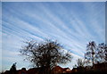
Sky stripes
Strange cirrus clouds in the morning sky
Image: © John Myers
Taken: 11 Jan 2009
0.16 miles
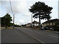
3
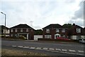
Houses on Eastwood Road, Rayleigh
Showing position of Postbox No. SS6 281.
See Image] for postbox.
Image: © JThomas
Taken: 25 Aug 2022
0.16 miles
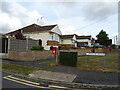
4
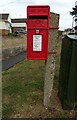
Elizabeth II postbox on Eastwood Road, Rayleigh
Postbox No. SS6 281.
See Image] for context.
Image: © JThomas
Taken: 25 Aug 2022
0.16 miles
6
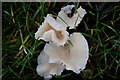
Snowy Wax Cap, Hygrocybe nivea
Fungi on my lawn
Image: © John Myers
Taken: 13 Dec 2009
0.22 miles
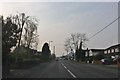
7
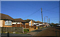
Connaught Road, Rayleigh
A road typical of the area, with no two houses quite the same and conspicuous power lines.
Image: © David Kemp
Taken: 13 Jan 2022
0.24 miles