IMAGES TAKEN NEAR TO
Meadowside, RAYLEIGH, SS6 8JB
Introduction
This page details the photographs taken nearby to Meadowside, SS6 8JB by members of the Geograph project.
The Geograph project started in 2005 with the aim of publishing, organising and preserving representative images for every square kilometre of Great Britain, Ireland and the Isle of Man.

There are currently over 7.5m images from over14,400 individuals and you can help contribute to the project by visiting https://www.geograph.org.uk
Image Map
Images are licensed for reuse under creativecommons.org/licenses/by-sa/2.0
Notes
- Clicking on the map will re-center to the selected point.
- The higher the marker number, the further away the image location is from the centre of the postcode.
Image Listing (55 Images Found)
Images are licensed for reuse under creativecommons.org/licenses/by-sa/2.0
Image
Details
Distance
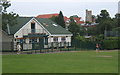
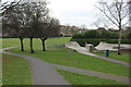
1
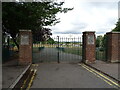
King George V playing field, Rayleigh
Not much play going on today though.
Image: © Robert Eva
Taken: 11 Jan 2017
0.10 miles
2
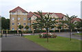
King Georges Court, Eastwood Road, Rayleigh
Viewed from alongside the Evangelical Church.
Image: © Andrew Hill
Taken: 24 Jun 2008
0.11 miles
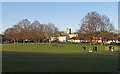
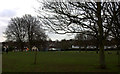
4
King George recreation ground, Rayleigh
Holy Trinity Church in the distance.
Image: © Andrew Hill
Taken: 24 Jun 2008
0.12 miles
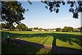
5
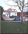
Skate park, King George's playing field
Small skate park in the town playing fields.
Image: © John Myers
Taken: 18 Feb 2007
0.12 miles
6
Skate park
A corner of King George V playing fields.
Image: © Robert Eva
Taken: 11 Jan 2017
0.14 miles
7
King George V Field
A recreation ground in the centre of Rayleigh
Image: © Glyn Baker
Taken: 26 Aug 2013
0.14 miles