IMAGES TAKEN NEAR TO
Parkway, RAYLEIGH, SS6 7PF
Introduction
This page details the photographs taken nearby to Parkway, SS6 7PF by members of the Geograph project.
The Geograph project started in 2005 with the aim of publishing, organising and preserving representative images for every square kilometre of Great Britain, Ireland and the Isle of Man.

There are currently over 7.5m images from over14,400 individuals and you can help contribute to the project by visiting https://www.geograph.org.uk
Image Map (Loading...)


Getting Data...Please wait
Leaflet Map data © OpenStreetMap
Images are licensed for reuse under creativecommons.org/licenses/by-sa/2.0
Notes
- Clicking on the map will re-center to the selected point.
- The higher the marker number, the further away the image location is from the centre of the postcode.
Image Listing (10 Images Found)
Images are licensed for reuse under creativecommons.org/licenses/by-sa/2.0
Image
Details
Distance
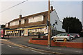
3
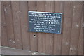
Memorial plaque at "Mac's Garage"
In the early hours of Saturday, September 12th 1987, a Beechcraft 200 Super King Air operated by National Airways, crash-landed on a car showroom in Eastwood Road, Rayleigh. The plane, piloted by 34 year old New Zealander, Hugh Forrester Brown, was just 3 minutes out of Southend Airport en route for Bergamo, Italy with a cargo of newspapers. In the fierce fire that followed the plane and the showroom were largely destroyed and the pilot died, the only casualty of the accident. I live about half a kilometre back along the flight path and was woken by a very low flying plane but went back to sleep only to be rewoken by sirens as the emergency services rushed to the scene. Only next morning did the sheer good fortune of local residents become apparent as the aircraft had hit the only unoccupied building in a tight-packed residential area. It is thought that the pilot had been attempting a landing on the Eastwood Road but had unfortunately missed that objective by a mere 15 metres.
Mac's did not long survive the incident and the rebuilt showroom is now a Vauxhall dealership.
Image: © John Myers
Taken: 14 Apr 2011
0.12 miles
4
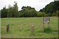
Lower Wyburns
This is Lower Wyburns Woodland Trust site initial planting was carried out by the local council who passed the site to the Trust http://www.woodlandtrust.org.uk/en/our-woods/Pages/wood-details.aspx?wood=4673&site=Lower-Wyburns The grid reference they give in their literature is on the wrong side of the A127 see Image
Image: © Glyn Baker
Taken: 26 Aug 2009
0.15 miles
5
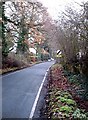
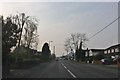
Daws Heath Road, Rayleigh
I wouldn't even try to do 60 mph down here. Narrow back road much used as a "rat-run" when the A127 is congested
Image: © John Myers
Taken: 23 Dec 2006
0.15 miles
6
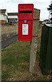
Elizabeth II postbox on Eastwood Road, Rayleigh
Postbox No. SS6 281.
See Image] for context.
Image: © JThomas
Taken: 25 Aug 2022
0.21 miles
8
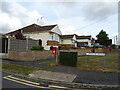
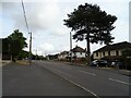
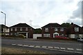
Houses on Eastwood Road, Rayleigh
Showing position of Postbox No. SS6 281.
See Image] for postbox.
Image: © JThomas
Taken: 25 Aug 2022
0.21 miles