IMAGES TAKEN NEAR TO
Tyndale Close, HOCKLEY, SS5 6NB
Introduction
This page details the photographs taken nearby to Tyndale Close, SS5 6NB by members of the Geograph project.
The Geograph project started in 2005 with the aim of publishing, organising and preserving representative images for every square kilometre of Great Britain, Ireland and the Isle of Man.

There are currently over 7.5m images from over14,400 individuals and you can help contribute to the project by visiting https://www.geograph.org.uk
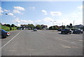
Image Map
Images are licensed for reuse under creativecommons.org/licenses/by-sa/2.0
Notes
- Clicking on the map will re-center to the selected point.
- The higher the marker number, the further away the image location is from the centre of the postcode.
Image Listing (56 Images Found)
Images are licensed for reuse under creativecommons.org/licenses/by-sa/2.0
Image
Details
Distance
6
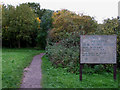
Kendal Park
This is the entrance to the Nature Reserve.
Image: © terry joyce
Taken: 29 Oct 2010
0.10 miles
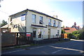
7
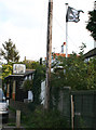
Jolly Roger
The flag is flying over The Smugglers Den Club.
Image: © terry joyce
Taken: 23 Oct 2007
0.10 miles
8
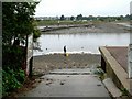
Slipway and Swans
This is the slipway at Hullbridge looking across the River Crouch towards Marsh Farm Country Park in South Woodham Ferrers
Image: © Glyn Baker
Taken: 11 Sep 2005
0.10 miles
9
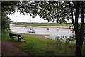
The River Crouch from Kendal Park
Looking across the River from Image
Image: © Glyn Baker
Taken: 29 Jun 2013
0.10 miles