IMAGES TAKEN NEAR TO
Ferry Road, HOCKLEY, SS5 6JJ
Introduction
This page details the photographs taken nearby to Ferry Road, SS5 6JJ by members of the Geograph project.
The Geograph project started in 2005 with the aim of publishing, organising and preserving representative images for every square kilometre of Great Britain, Ireland and the Isle of Man.

There are currently over 7.5m images from over14,400 individuals and you can help contribute to the project by visiting https://www.geograph.org.uk
Image Map
Images are licensed for reuse under creativecommons.org/licenses/by-sa/2.0
Notes
- Clicking on the map will re-center to the selected point.
- The higher the marker number, the further away the image location is from the centre of the postcode.
Image Listing (12 Images Found)
Images are licensed for reuse under creativecommons.org/licenses/by-sa/2.0
Image
Details
Distance
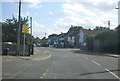
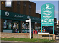
2

Public library, Hullbridge
On the corner of Ferry Road and Ambleside Gardens.
Image: © Robin Webster
Taken: 19 Apr 2015
0.07 miles
8
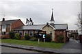
St Thomas of Canterbury, Parish Church of Hullbridge
Image: © Trevor Harris
Taken: 10 Mar 2009
0.16 miles
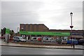
10
Malyons Lane
The CO-OP at the junction of Malyons Lane.
The Footpath Sign pointing toward Malyons Farm which it runs through.
Image: © terry joyce
Taken: 23 Oct 2007
0.23 miles