IMAGES TAKEN NEAR TO
Ferry Road, HOCKLEY, SS5 6EZ
Introduction
This page details the photographs taken nearby to Ferry Road, SS5 6EZ by members of the Geograph project.
The Geograph project started in 2005 with the aim of publishing, organising and preserving representative images for every square kilometre of Great Britain, Ireland and the Isle of Man.

There are currently over 7.5m images from over14,400 individuals and you can help contribute to the project by visiting https://www.geograph.org.uk
Image Map
Images are licensed for reuse under creativecommons.org/licenses/by-sa/2.0
Notes
- Clicking on the map will re-center to the selected point.
- The higher the marker number, the further away the image location is from the centre of the postcode.
Image Listing (20 Images Found)
Images are licensed for reuse under creativecommons.org/licenses/by-sa/2.0
Image
Details
Distance
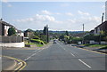
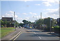
1
Ferry Road
This junction is the beginning of Ferry Road which is approximately 0.9 mile.
It runs from this point in Lower Road to the River Crouch, quite literally.
The road ends in a slipway into the river, see Image This road is the spine of Hullbridge, almost all the roads emanate from it.
Image: © terry joyce
Taken: 25 Oct 2010
0.07 miles
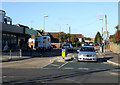
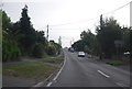
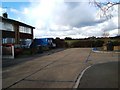
3
Budgens Supermarket
This smallish Supermarket is on a very busy junction served by a mini roundabout. It is on the corner of Ferry Road and Lower Road.
Image: © terry joyce
Taken: 25 Oct 2010
0.09 miles
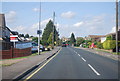
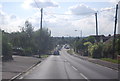
6
Coventry Hill, Hullbridge
This is looking down Coventry Hill towards the junction with Image
Image: © terry joyce
Taken: 25 Oct 2010
0.10 miles
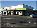
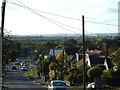
9
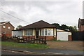
The Edge of Hullbridge
This is “The Priories” the point where the houses run out on the western edge of Hullbridge. How long before the field in the background is covered in desirable semis?
Image: © Glyn Baker
Taken: 28 Feb 2006
0.13 miles