IMAGES TAKEN NEAR TO
Lower Road, HOCKLEY, SS5 5LQ
Introduction
This page details the photographs taken nearby to Lower Road, SS5 5LQ by members of the Geograph project.
The Geograph project started in 2005 with the aim of publishing, organising and preserving representative images for every square kilometre of Great Britain, Ireland and the Isle of Man.

There are currently over 7.5m images from over14,400 individuals and you can help contribute to the project by visiting https://www.geograph.org.uk
Image Map
Images are licensed for reuse under creativecommons.org/licenses/by-sa/2.0
Notes
- Clicking on the map will re-center to the selected point.
- The higher the marker number, the further away the image location is from the centre of the postcode.
Image Listing (4 Images Found)
Images are licensed for reuse under creativecommons.org/licenses/by-sa/2.0
Image
Details
Distance
1
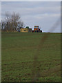
Lovedown Farm pillbox
Type FW3/22 hexagonal thick-walled pillbox overlooking fields towards the river at Hullbridge. It would have guarded against glider landings.
Image: © Julieanne Savage
Taken: 30 Dec 2007
0.20 miles
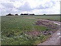
3
Arable field off Lower Road, Hullbridge
Image: © Roger Jones
Taken: 30 Jan 2022
0.22 miles
4
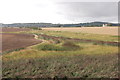
View from the seawall
South towards Hockley
Image: © John Myers
Taken: 25 Aug 2011
0.22 miles