IMAGES TAKEN NEAR TO
Tonbridge Road, HOCKLEY, SS5 5HL
Introduction
This page details the photographs taken nearby to Tonbridge Road, SS5 5HL by members of the Geograph project.
The Geograph project started in 2005 with the aim of publishing, organising and preserving representative images for every square kilometre of Great Britain, Ireland and the Isle of Man.

There are currently over 7.5m images from over14,400 individuals and you can help contribute to the project by visiting https://www.geograph.org.uk
Image Map
Images are licensed for reuse under creativecommons.org/licenses/by-sa/2.0
Notes
- Clicking on the map will re-center to the selected point.
- The higher the marker number, the further away the image location is from the centre of the postcode.
Image Listing (8 Images Found)
Images are licensed for reuse under creativecommons.org/licenses/by-sa/2.0
Image
Details
Distance
1
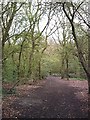
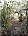
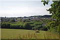
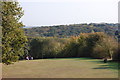
Beckney Wood - Footpath near S.W. Corner
Small wood on N. Hockley hills overlooking Crouch Valley.
Image: © John Myers
Taken: 14 Apr 2006
0.12 miles
4
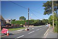
Road Works on Greensward Lane
This area seems well provided with Union Flags.
Image: © Glyn Baker
Taken: 26 Aug 2013
0.20 miles
7
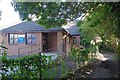
Greensward Surgery
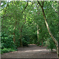
The path to the right is a bridleway
Image: © Glyn Baker
Taken: 26 Aug 2013
0.24 miles