IMAGES TAKEN NEAR TO
High Road, HOCKLEY, SS5 4SY
Introduction
This page details the photographs taken nearby to High Road, SS5 4SY by members of the Geograph project.
The Geograph project started in 2005 with the aim of publishing, organising and preserving representative images for every square kilometre of Great Britain, Ireland and the Isle of Man.

There are currently over 7.5m images from over14,400 individuals and you can help contribute to the project by visiting https://www.geograph.org.uk
Image Map
Images are licensed for reuse under creativecommons.org/licenses/by-sa/2.0
Notes
- Clicking on the map will re-center to the selected point.
- The higher the marker number, the further away the image location is from the centre of the postcode.
Image Listing (7 Images Found)
Images are licensed for reuse under creativecommons.org/licenses/by-sa/2.0
Image
Details
Distance
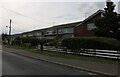
1
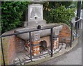
The Fountain
Junction of Fountain Lane and High Road, Hockley.
Image: © John Myers
Taken: 14 Aug 2006
0.10 miles
6
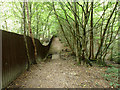
Boundary path, Hockley Woods
This appears to be a way out of the woods to Bullwood Approach.
Image: © Robin Webster
Taken: 7 Sep 2014
0.24 miles
7
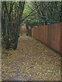
Beaches Wood
Footpath and fence in the north western part of Hockley Woods.
Image: © John Myers
Taken: 10 Nov 2007
0.25 miles