IMAGES TAKEN NEAR TO
Main Road, HOCKLEY, SS5 4NP
Introduction
This page details the photographs taken nearby to Main Road, SS5 4NP by members of the Geograph project.
The Geograph project started in 2005 with the aim of publishing, organising and preserving representative images for every square kilometre of Great Britain, Ireland and the Isle of Man.

There are currently over 7.5m images from over14,400 individuals and you can help contribute to the project by visiting https://www.geograph.org.uk
Image Map
Images are licensed for reuse under creativecommons.org/licenses/by-sa/2.0
Notes
- Clicking on the map will re-center to the selected point.
- The higher the marker number, the further away the image location is from the centre of the postcode.
Image Listing (12 Images Found)
Images are licensed for reuse under creativecommons.org/licenses/by-sa/2.0
Image
Details
Distance
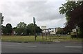
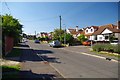
2

Hawkwell Common in Spring
Cherry tree blossom.
Image: © Lionel Barratt
Taken: 30 Mar 2009
0.06 miles
3

Hawkwell fire station
Hawkwell fire station, Main Road, Hawkwell, Hockley, Essex
Image: © Kevin Hale
Taken: 4 Jun 2010
0.07 miles
4
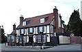
The White Hart public house, Hockley
A pause for refreshment on the Roach Valley Way, before the rigours of the Hockley Woods section.
Image: © John Myers
Taken: 9 Aug 2006
0.08 miles
5
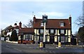
The White Hart Public House
Located at the junction of White Hart Lane and the B1013 Main Road.
Image: © terry joyce
Taken: 4 Feb 2009
0.10 miles
6
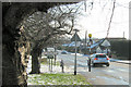
Hawkwell Common
Hawkwell Common from White Hart Lane.
Image: © Lionel Barratt
Taken: 3 Feb 2009
0.14 miles
7
Victor Gardens
This street was probably built on a former bridleway as it is marked on the map
as an "other route with public access"
Image: © Glyn Baker
Taken: 26 Aug 2013
0.19 miles
8
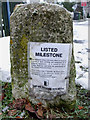
Listed Milestone
This note was attached to the side of the Milestone that is located on the B1013 'Main Road' approximately 70 metres from the junction of Tudor Way.
To see the front Image
To see its location Image
Image: © terry joyce
Taken: 6 Dec 2010
0.21 miles
9
Listed Milestone
A note was attached to the side of the Milestone that is located on the B1013 'Main Road' approximately 70 metres from the junction of Tudor Way.
See the note Image
To see its location Image
Image: © terry joyce
Taken: 6 Dec 2010
0.21 miles
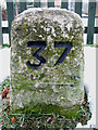
10
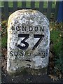
Old Milestone by the B1013, Main Road, Hawkwell
Carved stone post by the B1013, in parish of HAWKWELL (ROCHFORD District), Main Road, by No. 177, by the road, on Northwest side of road, next to Milestone Close. Erected by the Rochford Hundred (Div. of Essex First Dist) turnpike trust in the 19th century.
Inscription reads:-
LONDON
37
SOUTHEND
(6)
Grade II listed.
List Entry Number: 1112700 https://historicengland.org.uk/listing/the-list/list-entry/1112700
Milestone Society National ID: EX_RYRO37.
Image: © JV Nicholls
Taken: Unknown
0.21 miles