IMAGES TAKEN NEAR TO
Lark Hill Road, ROCHFORD, SS4 3RZ
Introduction
This page details the photographs taken nearby to Lark Hill Road, SS4 3RZ by members of the Geograph project.
The Geograph project started in 2005 with the aim of publishing, organising and preserving representative images for every square kilometre of Great Britain, Ireland and the Isle of Man.

There are currently over 7.5m images from over14,400 individuals and you can help contribute to the project by visiting https://www.geograph.org.uk
Image Map (Loading...)


Getting Data...Please wait
Leaflet Map data © OpenStreetMap
Images are licensed for reuse under creativecommons.org/licenses/by-sa/2.0
Notes
- Clicking on the map will re-center to the selected point.
- The higher the marker number, the further away the image location is from the centre of the postcode.
Image Listing (17 Images Found)
Images are licensed for reuse under creativecommons.org/licenses/by-sa/2.0
Image
Details
Distance
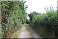
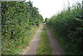
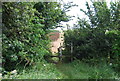
7
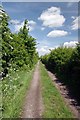
Lark Hill Avenue
This "Avenue" has "Plotland" development on each side of the hedge. It is part of the Roach Valley Way footpath that runs into Image
Image: © Glyn Baker
Taken: 25 May 2013
0.19 miles
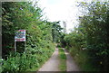
10
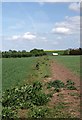
Roach Valley Way
Looking towards Image on the Roach Valley Way path http://www.ldwa.org.uk/ldp/members/show_path.php?path_name=Roach+Valley+Way
Image: © Glyn Baker
Taken: 25 May 2013
0.20 miles