IMAGES TAKEN NEAR TO
Apton Hall Road, ROCHFORD, SS4 3RQ
Introduction
This page details the photographs taken nearby to Apton Hall Road, SS4 3RQ by members of the Geograph project.
The Geograph project started in 2005 with the aim of publishing, organising and preserving representative images for every square kilometre of Great Britain, Ireland and the Isle of Man.

There are currently over 7.5m images from over14,400 individuals and you can help contribute to the project by visiting https://www.geograph.org.uk
Image Map (Loading...)


Getting Data...Please wait
Leaflet Map data © OpenStreetMap
Images are licensed for reuse under creativecommons.org/licenses/by-sa/2.0
Notes
- Clicking on the map will re-center to the selected point.
- The higher the marker number, the further away the image location is from the centre of the postcode.
Image Listing (19 Images Found)
Images are licensed for reuse under creativecommons.org/licenses/by-sa/2.0
Image
Details
Distance
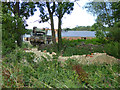
1
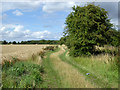
Footpath to Apton Hall Farm and beyond
This runs a small field width away to the right from the main drive, which is private.
Image: © Robin Webster
Taken: 30 Jul 2017
0.12 miles
2
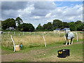
Paddocks by Apton Hall Road
The squat building on the left is one of the two lodges on Apton Hall Road each side of the drive to Apton Hall. The other is just peeping from behind the trees.
Image: © Robin Webster
Taken: 30 Jul 2017
0.12 miles
3
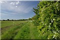
Footpath Near Apton HallFarm
The footpath to Whitehouse Farm
Image: © Glyn Baker
Taken: 25 May 2013
0.12 miles
4
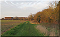
Path on arable field margin, nr Apton Hall Farm, Canewdon
Image: © Roger Jones
Taken: 29 Dec 2019
0.13 miles
5
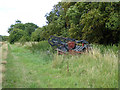
Set aside machinery, Apton Hall Farm
It is on a trailer.
Image: © Robin Webster
Taken: 30 Jul 2017
0.13 miles
6
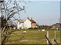
House in Apton Hall Road, near Canewdon
Taken looking north-west from a public footpath that passes over the flat fields behind the house.
Image: © David Kemp
Taken: 23 Mar 2006
0.17 miles
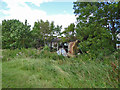
7
Apton Hall Farm
Some older buildings appear to be left to crumble, whilst others have been renovated. The planning permission for this was on the basis that they were to be used as a wedding venue. The farm appears to be divorcing itself from agriculture. There is an old mobile crane parked, in an army colour.
Image: © Robin Webster
Taken: 30 Jul 2017
0.17 miles
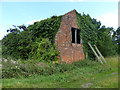
8
Derelict farm building
At Apton Hall Farm, where the older buildings appear to be left to crumble.
Image: © Robin Webster
Taken: 30 Jul 2017
0.18 miles
9
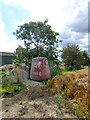
Navigation buoy, Apton Hall Farm
An unusual thing to be found in such a place. It appears to be accompanied by a load of mud, as if dredged from somewhere. The name looks like 'Ridge'. If so, it is from the approaches to the River Crouch, where it seems considerable re-buoying has taken place.
Image: © Robin Webster
Taken: 30 Jul 2017
0.19 miles
10
Derelict barn, Apton Hall Farm
There were a lot of new buildings at the farm, but the old buildings had been left to fall down.
Image: © Robin Webster
Taken: 30 Jul 2017
0.19 miles