IMAGES TAKEN NEAR TO
Apton Hall Road, ROCHFORD, SS4 3RG
Introduction
This page details the photographs taken nearby to Apton Hall Road, SS4 3RG by members of the Geograph project.
The Geograph project started in 2005 with the aim of publishing, organising and preserving representative images for every square kilometre of Great Britain, Ireland and the Isle of Man.

There are currently over 7.5m images from over14,400 individuals and you can help contribute to the project by visiting https://www.geograph.org.uk
Image Map (Loading...)


Getting Data...Please wait
Leaflet Map data © OpenStreetMap
Images are licensed for reuse under creativecommons.org/licenses/by-sa/2.0
Notes
- Clicking on the map will re-center to the selected point.
- The higher the marker number, the further away the image location is from the centre of the postcode.
Image Listing (9 Images Found)
Images are licensed for reuse under creativecommons.org/licenses/by-sa/2.0
Image
Details
Distance
1
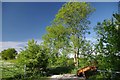
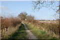
The Way to Canewdon
This is the Stambridge end of the Canewdon to Stambridge bridleway
Image: © Glyn Baker
Taken: 25 May 2013
0.05 miles
2
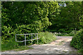
Footpath south of Canewdon
This is the bridge at which the footpath from Canewdon meets Apton Hall Road.
Image: © David Kemp
Taken: 31 May 2013
0.06 miles
3
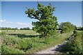
Approaching Apton Hall Rd
This bridleway links Canewdon and Sambridge
Image: © Glyn Baker
Taken: 25 May 2013
0.06 miles
4
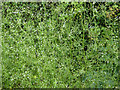
A delicate umbellifer
This is either Corn Parsley, Petroselinum segetum, or Stone Parsley, Sison amomum, both not often come across, but here prolific by a bridleway. These plants are in early flower, but the umbels are few-flowered anyway. I thought at first Corn Parsley, but have now veered towards the other, on looking them up. I rolled a picking between my fingers and the smell was oily rather than parsley-like, which indicates Stone Parsley.
Image: © Robin Webster
Taken: 30 Jul 2017
0.09 miles
5
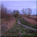
Track towards White House Farm
Taken from close by its junction with Apton Hall Lane. Canewdon Church can be seen on the skyline.
Image: © Trevor Harris
Taken: 10 Mar 2014
0.12 miles
6
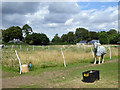
Free Range on Scotts Hall Farm
Happy looking pigs on Image
Image: © Glyn Baker
Taken: 25 May 2013
0.23 miles
7
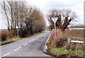
Scotts Hall Road, Canewdon
Taken at the junction with Apton Hall Road looking north. The boundary of the gridsquare runs a few feet to the south of the warning arrows on the bend. The barns of Scotts Hall farm itself are therefore just inside the adjoining square.
Image: © David Kemp
Taken: 12 Mar 2006
0.23 miles
8
Paddocks by Apton Hall Road
The squat building on the left is one of the two lodges on Apton Hall Road each side of the drive to Apton Hall. The other is just peeping from behind the trees.
Image: © Robin Webster
Taken: 30 Jul 2017
0.24 miles
9
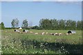
Path through arable land, nr Scott's Hall, Canewdon
Image: © Roger Jones
Taken: 29 Dec 2019
0.25 miles