IMAGES TAKEN NEAR TO
Fambridge Road, ROCHFORD, SS4 3LY
Introduction
This page details the photographs taken nearby to Fambridge Road, SS4 3LY by members of the Geograph project.
The Geograph project started in 2005 with the aim of publishing, organising and preserving representative images for every square kilometre of Great Britain, Ireland and the Isle of Man.

There are currently over 7.5m images from over14,400 individuals and you can help contribute to the project by visiting https://www.geograph.org.uk
Image Map (Loading...)


Getting Data...Please wait
Leaflet Map data © OpenStreetMap
Images are licensed for reuse under creativecommons.org/licenses/by-sa/2.0
Notes
- Clicking on the map will re-center to the selected point.
- The higher the marker number, the further away the image location is from the centre of the postcode.
Image Listing (49 Images Found)
Images are licensed for reuse under creativecommons.org/licenses/by-sa/2.0
Image
Details
Distance
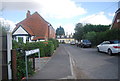
1
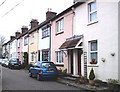
St. Thomas Road, South Fambridge
Terraced cottages tucked away behind the new development on the "main" road.
Image: © John Myers
Taken: 28 Jan 2007
0.01 miles
6
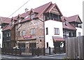
The Mews Bar and apartments, South Fambridge
This used to be the Anchor Hotel, far-famed for its Burns Night celebrations. Now a bar/restaurant with flats on top, it seems to have lost a lot in the conversion and is strangely incongruous in a place like Fambridge.
Image: © John Myers
Taken: 28 Jan 2007
0.06 miles
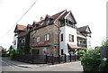
7
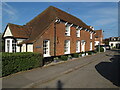
The Old Ferry House, South Fambridge (listed building)
Grade: II Listed building - List Entry Number: 1322377 https://historicengland.org.uk/listing/the-list/list-entry/1322377
Late C18, of earlier origin. Red brick. Hipped red plain tiled roof.
Image: © Roger Jones
Taken: 18 Apr 2021
0.06 miles
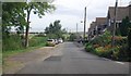
9

Pemberton Field
The village once had a small airfield which no longer exists, having been converted into this residential estate named Pemberton Field after Noel Pemberton Billing; who was an English aviator, inventor and Member of Parliament, responsible for founding the firm that became Supermarine.
Image: © terry joyce
Taken: 20 Feb 2009
0.06 miles
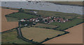
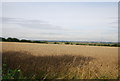
10
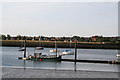
Looking across to South Fambridge
This is where a ferry used to cross the Crouch Estuary from North Fambridge to the much more populated South Fambridge. I have been unable to find the exact date the ferry ceased trading, but a local suggested 'about 1955'.
Image: © Dr Neil Clifton
Taken: 11 Aug 2006
0.07 miles