IMAGES TAKEN NEAR TO
Albert Road, ROCHFORD, SS4 3EZ
Introduction
This page details the photographs taken nearby to Albert Road, SS4 3EZ by members of the Geograph project.
The Geograph project started in 2005 with the aim of publishing, organising and preserving representative images for every square kilometre of Great Britain, Ireland and the Isle of Man.

There are currently over 7.5m images from over14,400 individuals and you can help contribute to the project by visiting https://www.geograph.org.uk
Image Map (Loading...)


Getting Data...Please wait
Leaflet Map data © OpenStreetMap
Images are licensed for reuse under creativecommons.org/licenses/by-sa/2.0
Notes
- Clicking on the map will re-center to the selected point.
- The higher the marker number, the further away the image location is from the centre of the postcode.
Image Listing (5 Images Found)
Images are licensed for reuse under creativecommons.org/licenses/by-sa/2.0
Image
Details
Distance
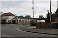
1
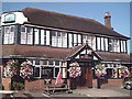
The Victory Inn, Ashingdon
Newish pub ( by local standards anyway) on main road through village.
Image: © John Myers
Taken: 10 Sep 2006
0.13 miles
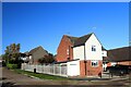
3
Richmond Avenue, Hawkwell
Taken looking north towards Wedgwood Way.
Image: © David Kemp
Taken: 13 Nov 2023
0.19 miles
5
The Elim Pentecostal Church, Ashingdon
Image: © David Howard
Taken: 26 Jul 2020
0.23 miles