IMAGES TAKEN NEAR TO
Magnolia Road, ROCHFORD, SS4 3AD
Introduction
This page details the photographs taken nearby to Magnolia Road, SS4 3AD by members of the Geograph project.
The Geograph project started in 2005 with the aim of publishing, organising and preserving representative images for every square kilometre of Great Britain, Ireland and the Isle of Man.

There are currently over 7.5m images from over14,400 individuals and you can help contribute to the project by visiting https://www.geograph.org.uk
Image Map
Images are licensed for reuse under creativecommons.org/licenses/by-sa/2.0
Notes
- Clicking on the map will re-center to the selected point.
- The higher the marker number, the further away the image location is from the centre of the postcode.
Image Listing (38 Images Found)
Images are licensed for reuse under creativecommons.org/licenses/by-sa/2.0
Image
Details
Distance
1
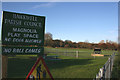
Magnolia Play Space
There is a small play area and a field leading to the Nature Reserve.
Image: © terry joyce
Taken: 26 Nov 2010
0.01 miles
2
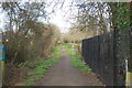
Footpath leading to Magnolia Park
Looking north from Magnolia Road.
Image: © Trevor Harris
Taken: 10 Mar 2014
0.04 miles
3
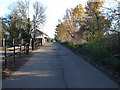
Magnolia Road
This is taken at the junction of Image, looking back towards Rectory Road.
Image: © terry joyce
Taken: 26 Nov 2010
0.04 miles
4
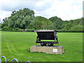
A memorial to Hawkwell's "mining" past
Reflecting Magnolia Park's former use as a sand and gravel pit.
Image: © John Myers
Taken: 8 Jul 2009
0.05 miles
5

Colourful Mural
This is part of a painted wall in the car park of Image There were cars parked in front of the rest of the wall.
Image: © terry joyce
Taken: 26 Nov 2010
0.05 miles
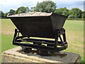
6
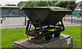
Narrow gauge skip in recreation ground, Hawkwell
This remembers that the field was the site of Hawkwell Brickworks, and the nature reserve beyond was where the clay was won. The enterprise closed around 1959, the skip came from elsewhere - possibly nearby Cherry Orchard Lane or Star Lane brickworks, which closed much later. The sign merely says 'Do not climb'.
Image: © Robin Webster
Taken: 30 Jul 2017
0.05 miles
7
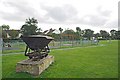
Tipping hopper, Magnolia Fields Local Nature Reserve, Hawkwell
This is a typical narrow-gauge contractor's tipping hopper built in the thousands and used for the transport of materials around a site. In this instance, probably used to carry brick clay from the fields to the works/kilns.
Sometimes known as Magnolia Park, this wagon is a reminder that this area was once industrial, much of this area was originally a brickworks, where both sand and clay were extracted.
Image: © Roger Jones
Taken: 18 May 2022
0.06 miles
8
Magnolia Park
Magnolia Park and The Magnolia Nature reserve see
http://www.wildessex.net/sites/Magnolia%20Nature%20Reserve.htm are built on the site of a former Brickworks. Here you can see illustrations of the past and current usage.
Image: © Glyn Baker
Taken: 18 Sep 2010
0.06 miles
9
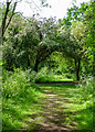
Path in Magnolia Fields Local Nature Reserve, Hawkwell
Sometimes known as Magnolia Park, this Nature Reserve is managed by Hawkwell Parish Council. The reserve was former brickworks.
Rochford district: https://www.rochford.gov.uk/leisure-and-tourism/woodlands-parks-and-open-spaces/magnolia-nature-reserve
Wild Essex: https://www.wildessex.net/sites/Magnolia%20Nature%20Reserve.htm
Image: © Roger Jones
Taken: 18 May 2022
0.08 miles
10
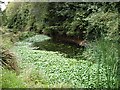
Wildlife pond - Magnolia Park, Hawkwell
Site of old gravel pit. Now a playspace and nature reserve administered by Hawkwell Parish Council.
Image: © John Myers
Taken: 31 Aug 2006
0.09 miles