IMAGES TAKEN NEAR TO
Paglesham Road, ROCHFORD, SS4 2DG
Introduction
This page details the photographs taken nearby to Paglesham Road, SS4 2DG by members of the Geograph project.
The Geograph project started in 2005 with the aim of publishing, organising and preserving representative images for every square kilometre of Great Britain, Ireland and the Isle of Man.

There are currently over 7.5m images from over14,400 individuals and you can help contribute to the project by visiting https://www.geograph.org.uk
Image Map
Images are licensed for reuse under creativecommons.org/licenses/by-sa/2.0
Notes
- Clicking on the map will re-center to the selected point.
- The higher the marker number, the further away the image location is from the centre of the postcode.
Image Listing (32 Images Found)
Images are licensed for reuse under creativecommons.org/licenses/by-sa/2.0
Image
Details
Distance
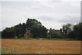
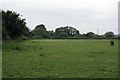
1
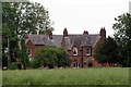
Ingulfs
Looking across a field of oilseed rape towards a substantial late Victorian or Edwardian villa. Ingulf was the Benedictine abbot of Crowland Abbey in Lincolnshire who died in 1109. I wonder if this estate is somehow linked to the order?
Image: © Glyn Baker
Taken: 4 Jun 2016
0.01 miles
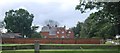
7
Paddock by West Hall Farm
You can see the farm buildings in the background.
Image: © Glyn Baker
Taken: 4 Jun 2016
0.06 miles
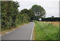
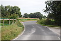
8
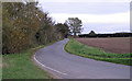
Road to Church End, Paglesham
Rural road through arable land.
Image: © Roger Jones
Taken: 20 Oct 2019
0.07 miles