IMAGES TAKEN NEAR TO
Stambridge, ROCHFORD, SS4 2AS
Introduction
This page details the photographs taken nearby to SS4 2AS by members of the Geograph project.
The Geograph project started in 2005 with the aim of publishing, organising and preserving representative images for every square kilometre of Great Britain, Ireland and the Isle of Man.

There are currently over 7.5m images from over14,400 individuals and you can help contribute to the project by visiting https://www.geograph.org.uk
Image Map (Loading...)


Getting Data...Please wait
Leaflet Map data © OpenStreetMap
Images are licensed for reuse under creativecommons.org/licenses/by-sa/2.0
Notes
- Clicking on the map will re-center to the selected point.
- The higher the marker number, the further away the image location is from the centre of the postcode.
Image Listing (7 Images Found)
Images are licensed for reuse under creativecommons.org/licenses/by-sa/2.0
Image
Details
Distance
1
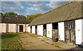
Stables near Hampton Barns, Great Stambridge
Image: © Roger Jones
Taken: 8 Sep 2019
0.02 miles
2
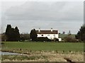
Farm cottages at Hampton Barns, near Great Stambridge
Taken from the Roach Valley Way footpath looking north.
Image: © David Kemp
Taken: 15 Feb 2006
0.07 miles
3
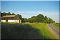
Farm Road at Hampton Barns
There really are barns at Hampton Barns! The right of way cuts through paddocks to the south I am sure the landowner would prefer to keep walkers on the road.
Image: © Glyn Baker
Taken: 19 Aug 2012
0.07 miles
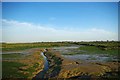
4

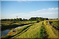
View from Sea Wall, Bartonhall Creek, Great Stambridge
Image: © Roger Jones
Taken: 8 Sep 2019
0.09 miles
5
The End Of Barton Hall Creek
Taken from Image at low tide.
Image: © Glyn Baker
Taken: 19 Aug 2012
0.12 miles
7
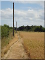
Footpath to Hampton Barns
Path from Gt. Stambridge village.
Image: © John Myers
Taken: 11 Jul 2010
0.19 miles