IMAGES TAKEN NEAR TO
Hall Road, ROCHFORD, SS4 1PL
Introduction
This page details the photographs taken nearby to Hall Road, SS4 1PL by members of the Geograph project.
The Geograph project started in 2005 with the aim of publishing, organising and preserving representative images for every square kilometre of Great Britain, Ireland and the Isle of Man.

There are currently over 7.5m images from over14,400 individuals and you can help contribute to the project by visiting https://www.geograph.org.uk
Image Map
Images are licensed for reuse under creativecommons.org/licenses/by-sa/2.0
Notes
- Clicking on the map will re-center to the selected point.
- The higher the marker number, the further away the image location is from the centre of the postcode.
Image Listing (14 Images Found)
Images are licensed for reuse under creativecommons.org/licenses/by-sa/2.0
Image
Details
Distance
1
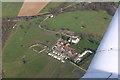
The Lawn
The Lawn is a venue for Weddings etc.
Top left of picture is in TQ853910. Top right TQ852904.
Bottom left TQ847906. Bottom right (not including wing of plane) TQ849904.
Image: © terry joyce
Taken: 8 Mar 2007
0.07 miles
2

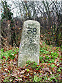
Old Milestone by the B1013, Hall Road, Hawkwell,
Carved stone post by the B1013, in parish of HAWKWELL (ROCHFORD District), Hall Road, 100m North of Hall Road cemetery, near the entrance to The Lawn, by the road, on Northeast side of road. Erected by the Rochford Hundred (Div. of Essex First Dist) turnpike trust in the 19th century.
Inscription reads:-
LONDON
38
SOUTHEND
5
Carved benchmark on left side.
Grade II listed.
List Entry Number: 1307132 https://historicengland.org.uk/listing/the-list/list-entry/1307132
Milestone Society National ID: EX_RYRO38.
Image: © JV Nicholls
Taken: Unknown
0.15 miles
3
M for ?
M is for ? - Judging by the smell, it was pretty clear.
Image: © Paul Collins
Taken: 5 Aug 2007
0.15 miles
4
Listed Milestone
This Milestone is a Grade II listed building.
It is located in Hall Road, Rochford opposite the entrance to Image
See http://www.milestonesociety.co.uk
Image: © terry joyce
Taken: 30 Dec 2010
0.15 miles
5
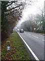
Hall Road
This is a section of Hall Road in Rochford. See the Image This road links Hockley with Rochford and Southend.
Image: © terry joyce
Taken: 30 Dec 2010
0.16 miles
6
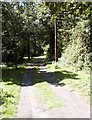
Ark Lane, Stroud Green
Country lane, looking West.
Image: © Paul Collins
Taken: 5 Aug 2007
0.16 miles
7
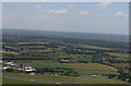
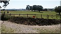
Essex Countryside
The centre of the picture is in this grid and the prominent feature is Image Get out your magnifying glass.
The runway at Southend Airport is seen at the bottom of the picture.
Image: © terry joyce
Taken: 22 Jun 2008
0.17 miles
8
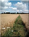
Roach Valley Way
North through vast wheat-fields.
Image: © John Myers
Taken: 24 Jul 2007
0.18 miles
9
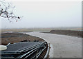
Hall Road Cemetery
The cemetery in Hall Road, Rochford is liable to reach capacity in the next twenty years, so an extension is being created on land north of the current cemetery. This is the new access road.
Image: © terry joyce
Taken: 30 Dec 2010
0.18 miles
10

Footpath junction near The Lawn, Rochford
Image: © Roger Jones
Taken: 29 May 2022
0.21 miles