
IMAGES TAKEN NEAR TO
Warwick Drive, ROCHFORD, SS4 1HW
Introduction
This page details the photographs taken nearby to Warwick Drive, SS4 1HW by members of the Geograph project.
The Geograph project started in 2005 with the aim of publishing, organising and preserving representative images for every square kilometre of Great Britain, Ireland and the Isle of Man.

There are currently over 7.5m images from over14,400 individuals and you can help contribute to the project by visiting https://www.geograph.org.uk
Image Map
Images are licensed for reuse under creativecommons.org/licenses/by-sa/2.0
Notes
- Clicking on the map will re-center to the selected point.
- The higher the marker number, the further away the image location is from the centre of the postcode.
Image Listing (7 Images Found)
Images are licensed for reuse under creativecommons.org/licenses/by-sa/2.0
Image
Details
Distance
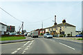
2
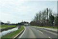
Sutton Road
Heading into the fringes of Rochford. A recently cleaned ditch on the left, with beyond the river bank for the Prittle Brook, which is still tidal here.
Image: © Robin Webster
Taken: 6 Apr 2018
0.15 miles
3
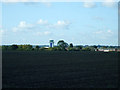
Field with a view
This field is on Sutton Road near to Shopland Road. The new Tower at Southend Airport, which is in grid TQ8789 can be seen in the distance.
Image: © terry joyce
Taken: 20 Oct 2010
0.20 miles
4
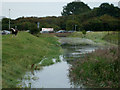
Prittle Brook
This is where Prittle Brook passes under Sutton Road by Purdey's Industrial Estate.
It is tidal at this point.
Image: © terry joyce
Taken: 31 Aug 2011
0.21 miles
5
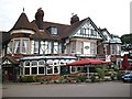
The Anne Boleyn, Rochford
Pub/restaurant honouring Rochford's most famous daughter.
Image: © John Myers
Taken: 23 Aug 2006
0.21 miles
6
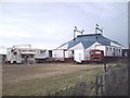
Big Top
The Great British Circus.... now playing Rochford!
Image: © John Myers
Taken: 23 Aug 2006
0.25 miles
