
IMAGES TAKEN NEAR TO
Stephen Place, ROCHFORD, SS4 1GW
Introduction
This page details the photographs taken nearby to Stephen Place, SS4 1GW by members of the Geograph project.
The Geograph project started in 2005 with the aim of publishing, organising and preserving representative images for every square kilometre of Great Britain, Ireland and the Isle of Man.

There are currently over 7.5m images from over14,400 individuals and you can help contribute to the project by visiting https://www.geograph.org.uk
Image Map
Images are licensed for reuse under creativecommons.org/licenses/by-sa/2.0
Notes
- Clicking on the map will re-center to the selected point.
- The higher the marker number, the further away the image location is from the centre of the postcode.
Image Listing (7 Images Found)
Images are licensed for reuse under creativecommons.org/licenses/by-sa/2.0
Image
Details
Distance
1
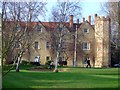
Rochford Hall
A view of the Hall with golfers in front.
Image: © Julieanne Savage
Taken: 10 Dec 2006
0.07 miles
2
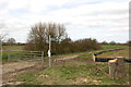
Public bridleway to Ironwell Lane
Taken from its junction with the road between Stroud Green and Rochford.
Image: © Trevor Harris
Taken: 10 Mar 2014
0.10 miles
4
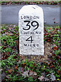
Refurbished Milestone
This refurbished Milestone is in Hall Road, Rochford.
See http://www.milestonesociety.co.uk
Image: © terry joyce
Taken: 30 Dec 2010
0.23 miles
5
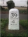
Old Milestone on Hall Road, Rochford
Carved stone post by the UC road (was B1013), in parish of Rochford (Rochford District), Hall Road, on the verge on the East side of the road between path and road. Erected by the Rochford Hundred (Div of Essex First Dist) turnpike trust in the 19th century.
Re-located to right hand side of housing estate entrance after 2012.
Inscription reads:-
LONDON
39
SOUTHEND
4
MILES
Carved benchmark on top.
Grade II listed.
List Entry Number: 1322383 https://historicengland.org.uk/listing/the-list/list-entry/1322383
Milestone Society National ID: EX_RYRO39.
Image: © JV Nicholls
Taken: Unknown
0.25 miles
6
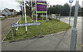
Old Milestone on Hall Road, Rochford
Carved stone post by the UC road (was B1013), in parish of Rochford (Rochford District), Hall Road, on the verge on the East side of the road between path and road. Erected by the Rochford Hundred (Div of Essex First Dist) turnpike trust in the 19th century.
Re-located to right hand side of housing estate entrance after 2012.
Inscription reads:-
LONDON
39
SOUTHEND
4
MILES
Carved benchmark on top.
Grade II listed.
List Entry Number: 1322383 https://historicengland.org.uk/listing/the-list/list-entry/1322383
Milestone Society National ID: EX_RYRO39.
Image: © Michael Bardell
Taken: 20 Feb 2021
0.25 miles
7
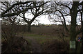
Path towards Stroud Green
This is where it branches off from Ironwell Lane
Image: © Robert Eva
Taken: 11 Jan 2017
0.25 miles