IMAGES TAKEN NEAR TO
Lingfield Drive, ROCHFORD, SS4 1DZ
Introduction
This page details the photographs taken nearby to Lingfield Drive, SS4 1DZ by members of the Geograph project.
The Geograph project started in 2005 with the aim of publishing, organising and preserving representative images for every square kilometre of Great Britain, Ireland and the Isle of Man.

There are currently over 7.5m images from over14,400 individuals and you can help contribute to the project by visiting https://www.geograph.org.uk
Image Map
Images are licensed for reuse under creativecommons.org/licenses/by-sa/2.0
Notes
- Clicking on the map will re-center to the selected point.
- The higher the marker number, the further away the image location is from the centre of the postcode.
Image Listing (7 Images Found)
Images are licensed for reuse under creativecommons.org/licenses/by-sa/2.0
Image
Details
Distance
1
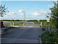
Gate on Doggetts Chase, Rochford
A private road but public footpath.
Image: © Robin Webster
Taken: 19 Apr 2015
0.08 miles
2
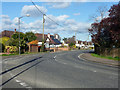
Bend on Stambridge Road, Rochford
Stilwells is off to the left.
Image: © Robin Webster
Taken: 19 Apr 2015
0.10 miles
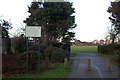
3
Doggetts Chase
A private road but public footpath.
Image: © Robin Webster
Taken: 19 Apr 2015
0.15 miles
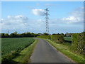
5
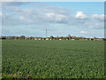
Field east of Doggetts Chase
It looks like wheat.
Image: © Robin Webster
Taken: 19 Apr 2015
0.19 miles
6
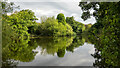
Fishing lake, Doggetts Wildlife Area, Rochford
Named after the nearby farm: https://www.rochfordparishcouncil.gov.uk/community-facilities/doggetts-wildlife-area/
Image: © Roger Jones
Taken: 30 May 2022
0.24 miles
7
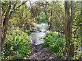
Flooded path
This, the nearest approximation to the mapped public path, is impassable without wellingtons, and even then doubtful. The practical through route these days is further north.
Image: © Robin Webster
Taken: 19 Apr 2015
0.25 miles