IMAGES TAKEN NEAR TO
The Garners, ROCHFORD, SS4 1DS
Introduction
This page details the photographs taken nearby to The Garners, SS4 1DS by members of the Geograph project.
The Geograph project started in 2005 with the aim of publishing, organising and preserving representative images for every square kilometre of Great Britain, Ireland and the Isle of Man.

There are currently over 7.5m images from over14,400 individuals and you can help contribute to the project by visiting https://www.geograph.org.uk
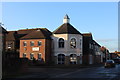
Image Map
Images are licensed for reuse under creativecommons.org/licenses/by-sa/2.0
Notes
- Clicking on the map will re-center to the selected point.
- The higher the marker number, the further away the image location is from the centre of the postcode.
Image Listing (64 Images Found)
Images are licensed for reuse under creativecommons.org/licenses/by-sa/2.0
Image
Details
Distance
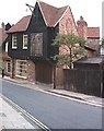
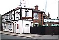
1
Round house at the end of Millview Meadows
Image: © Robert Eva
Taken: 11 Jan 2017
0.06 miles
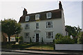
4
Merchant's house, East Street
House in the old town.
Image: © John Myers
Taken: 20 Aug 2006
0.12 miles
5
The New Ship
In Ship Lane behind the Old Ship which is in North Street.
Image: © John Myers
Taken: 20 Aug 2006
0.13 miles
6
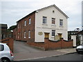
Rochford Congregational Church
The Church is in North Street and the building dates from 1741. This Church's website is here http://rochfordcongregational.co.uk/index.htm
Image: © Nigel Cox
Taken: 3 Aug 2008
0.13 miles
7
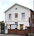
Rochford Congregational Church
North Street.
Image: © John Myers
Taken: 19 Aug 2006
0.13 miles
8
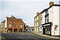
South & East Streets Rochford
Looking from South St towards the Gray Goose in East St
Image: © Glyn Baker
Taken: 19 Aug 2012
0.14 miles
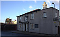
9
Rochford: Castle Point & Rochford Adult Community College
The carving over the lintel of the main door of this building in Rocheway shows a date of 1937 and the three seaxe emblem of Essex County Council, and it would appear therefore to have been built as a school or college but there is no obvious evidence in Google as to its origins. We certainly did not have adult community colleges in 1937!
Postscript 26 October 2008:
A viewer of the caption has written to me to say:
"Your photo of Rochford Adult Education College brought back memories and surprise that its origin was unknown. You are quite correct in that it was built as a school. It was Rochford Secondary Modern School. I was a pupil there from 1952 - 1956. It closed as a children's school sometime in the early 60's due to fear of aircraft crashing on the approach to Rochford - now Southend - airport. The noise was also a factor."
Image: © Nigel Cox
Taken: 3 Aug 2008
0.14 miles
10
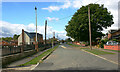
Rocheway, Rochford
Taken looking west towards the town. The houses behind the railings on the left are in College Gardens. They stand on the site of the former Castlepoint & Rochford Adult Education College which was housed in a former primary school whose buildings dated from 1937. The College was relocated in 2014 and the buildings subsequently demolished. Construction of the new houses began in 2020.
Image: © David Kemp
Taken: 28 Sep 2022
0.14 miles