IMAGES TAKEN NEAR TO
West Street, ROCHFORD, SS4 1AU
Introduction
This page details the photographs taken nearby to West Street, SS4 1AU by members of the Geograph project.
The Geograph project started in 2005 with the aim of publishing, organising and preserving representative images for every square kilometre of Great Britain, Ireland and the Isle of Man.

There are currently over 7.5m images from over14,400 individuals and you can help contribute to the project by visiting https://www.geograph.org.uk
Image Map (Loading...)


Getting Data...Please wait
Leaflet Map data © OpenStreetMap
Images are licensed for reuse under creativecommons.org/licenses/by-sa/2.0
Notes
- Clicking on the map will re-center to the selected point.
- The higher the marker number, the further away the image location is from the centre of the postcode.
Image Listing (115 Images Found)
Images are licensed for reuse under creativecommons.org/licenses/by-sa/2.0
Image
Details
Distance
1
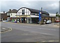
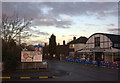
Rochford: Whittingham's Garage
Whittinghams is a traditional type of garage where they serve your fuel to you. For the record the prices here on this day were £1.21 per litre for petrol and £1.35 per litre for diesel. The address is 84 West Street, yet old maps definitely describe the road as Church Street. The garage was built in 1924.
Image: © Nigel Cox
Taken: 3 Aug 2008
0.01 miles
2
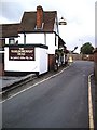
The Marlborough Head, Rochford
From Back Lane.
Image: © John Myers
Taken: 20 Aug 2006
0.02 miles
3
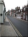
West Street, Rochford
The "High Street" by any other name. Most of the town's shops are in this road and the market square at the top.
Image: © John Myers
Taken: 20 Aug 2006
0.02 miles
4
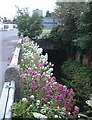
Bradley Way Culvert
Bright floral border hides a tributary of the River Roach in a rather ugly concrete culvert.
Image: © John Myers
Taken: 18 Jun 2008
0.02 miles
5
Road junction sign and Whittingham's garage
Image: © Robert Eva
Taken: 11 Jan 2017
0.03 miles
6
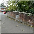
Old Boundary Marker
Bridge Marker, a carved stone plaque set in the eastern parapet of the bridge on Hall Road over the River Roach, just south of the junction with Church Street. Rochford parish. Inscribed 1777 and moved from the bridge demolished in 1970.
REPORTED BY, AND POSTED IN MEMORY OF, JOHN V NICHOLLS 1943 – 2020
Milestone Society National ID: EX_ROCH01br
Image: © M Bardell
Taken: 16 Oct 2020
0.04 miles
8
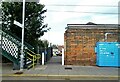
Disabled access ramp
Rochford railway station
Image: © John Myers
Taken: 8 Jan 2012
0.05 miles
9
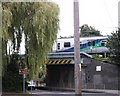
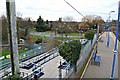
Leaving Rochford Station
Train leaving Rochford for London, across Hall Road Railway Bridge.
Image: © Paul Collins
Taken: 2 Aug 2007
0.05 miles
10

Rochford station
Opened in 1889 by the Great Eastern Railway on its branch line from Shenfield to Southend opened the same year.
Image: © David Kemp
Taken: 24 Jun 2018
0.06 miles